Bookmarks

Showing Bookmarks 1 to 22 of 22

  • McCarthy Album 10, Photograph 379

    Caption: "Hermoso [sic] Dorothy Gandy. A youthful Mexican beauty."

    Date: 1938

  • McCarthy Album 01, Photograph 051

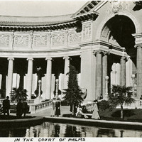
    Caption: "In the Court of Palms," at the Panama-Pacific International Exposition.

    Date: 1915

  • Campo de los Franceses Rancho

    Hand-drawn sketch map of Campo de los Franceses boundaries. Volume 2, page 33.

    Date: 1843

  • McCarthy Album 10, Photograph 163

    Caption: "Two Medicine Lake and Rockwell Mountain - Glacier Park," c. 1935.

    Date: 1935

  • McCarthy Album 11, Photograph 211

    Caption: "The Ghetto. Where People Almost Live on the Street, New York City, Aug. 12, 1934." Crowded street scene in New York City, with numerous open-air stalls and storefronts hawking wares.

    Date: 8/12/1934

  • McCarthy Album 10, Photograph 079

    Caption: "In Ford Building Court, San Diego Exposition," 1935, shows William and Grace McCarthy sitting near a fountain in the Ford Building Court, at the California-Pacific International Exposition.

    Date: 1935

  • Canada de la Berrenda Rancho

    Hand-drawn sketch map of Canada de la Berrenda boundaries. Volume 2, page 195.

    Date: 1846

  • McCarthy Album 09, Photograph 211

    Caption: "Obelisk - Central Park," c. 1925. The obelisk in this photograph was erected in Central Park on February 22nd, 1881. It is an authentic Ancient Egyptian artifact, having been created during the rule of Thusmose III in the 18th Dynasty (despite the nickname, the obelisk has no known connection to Cleopatra). It was acquired in 1877 as a gift from the Egyptian Khedive.

    Date: 1925

  • McCarthy Album 10, Photograph 160

    Caption: "Saint Mary's Lake and going to the Sun Mountain. Glacier National Park," c. 1935.

    Date: 1935

  • McCarthy Album 08, Photograph 001

    Caption: "Government building, Victoria, B.C.," c. 1908-1912. View of the British Columbia Parliament Buildings in Victoria. Designed by Francis Rattenbury, the construction began on the complex in 1893 and finished four years later. The buildings were first used in 1898.

    Date: 1908

  • McCarthy Album 09, Photograph 225

    Caption: "Congressional Library," c. 1925. Several groups of unidentified people outside the Thomas Jefferson Building of the Library of Congress, on a rainy day. The building, originally called the Library of Congress Building, opened to the public in 1897. It's name was changed in 1980 to honor Thomas Jefferson, Founding Father and third President of the U.S.

    Date: 1925

  • McCarthy Album 08, Photograph 167

    No Caption: c. 1910. Side view of a heavy coastal defense disappearing gun. Retracting or disappearing guns were a form of artillery developed in the nineteenth century in which heavy artillery guns were placed on rotating carriages that allowed retraction of the weapon after firing, to enable reloading while under enemy fire.

    Date: 1910

  • Cañada de los Osos y Pecho y Islae Rancho

    Hand-drawn sketch map of Cañada de los Osos y Pecho y Islae boundaries. Volume 1, page 700.

    Date: 1842

  • Alamos Rancho

    Hand-drawn sketch map of Alamos boundaries. Volume 1, page 302.

    Date: 1838

  • McCarthy Album 05, Photograph 286

    Caption: "A Holdup," c. 1910. Grace McCarthy standing in a yard or garden aiming a rifle at an unseen target.

    Date: 1910

  • McCarthy Album 07, Photograph 207

    Caption: "Court House - Los Angeles." c. 1915-1920. The Los Angeles County Courthouse, also known as the Red Sandstone Courthouse, was completed in 1891. Located at the southeast corner of Temple and Broadway, the courthouse was damaged beyond repair by the 1933 Long Beach earthquake and demolished in 1936. To the left of the courthouse stands the Hall of Records, built in 1911 and used, along with other buildings, as the county courthouse from 1934 until 1959, when the current courthouse was occupied. The Hall of Records was demolished in 1973. See also 96-07-08-alb01-147.

    Date: 1915

  • McCarthy Album 09, Photograph 230

    Caption: "Unknown Soldiers Grave - Arlington Cemetry[sic]," c. 1925. The Tomb of the Unknown Soldier, also called the Tomb of the Unknowns, memorializes those U.S. military service members who died without their remains being later identified. The remains of the first Unknown Soldier, stemming from World War I and disinterred from a cemetery in France, were laid to rest in the tomb in 1921.

    Date: 1925

  • McCarthy Album 04, Photograph 122

    Caption: "Freight Transportation -- Tiajuana [sic], Mexico," c. 1915-1916. Three donkeys loaded with packs of what appear to be firewood.

    Date: 1915

  • McCarthy Album 11, Photograph 124b

    Caption: "Morro Castle -- Havana -- Cuba. July 4, 1934." Morro Castle, also called Castillo de los Tres Reyes Magos del Morro, has guarded the entrance to Havana's harbor since 1589. Various additions have been built over the years, including the Faro Castillo del Morro Lighthouse, added in 1846. Morro Castle currently houses the offices of the Havana Harbormaster, and operates as a museum.

    Date: 7/4/1934

  • McCarthy Album 03, Photograph 080

    Caption: "Cliff House." People standing on Ocean Beach watching the third Cliff House burning in San Francisco, in 1907. The original Cliff House was built in 1858. The second was built in 1863 and was destroyed by fire on Christmas day in 1894. The third Victorian- style Cliff House was completed in 1896, and although it survived the 1906 earthquake and fires, it burned to the ground in 1907, as seen in this image. A fourth Cliff House was then built with steel-reinforced concrete and opened in 1909.

    Date: 1907

  • McCarthy Album 09, Photograph 069

    Caption: "Seven Falls - Colorado Springs," c. 1923. View from the top of a narrow wooden staircase, looking back down onto a resort building and a small creek. The stairs lead to a series of seven cascading waterfalls of South Cheyenne Creek. The area has been a privately-owned tourist attraction since the 1880s.

    Date: 1923

  • Cañada de los Nogales Rancho

    Hand-drawn sketch map of Cañada de los Nogale boundaries. Volume 2, page 67.

    Date: 1844