
Bookmarks
Showing Bookmarks 1 to 4 of 4
-
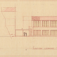
Caption: "Section Looking North and Section Looking South." Color drawing of intermediate girls' dormitory, California School for the Deaf at Berkeley. Design and drawing by Alfred Eichler, 1944; built in 1946. Project for Department of Education.
Date: 1944
-
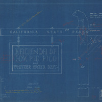
Caption: "Sign for California State Parks." Blueline of drawing by Alfred Eichler of sign for hacienda of Governor Pio Pico, California State Parks, after design by Colonel Wing, Chief Division of Parks. Includes handwritten note attached to drawing and additional annotations. Project for Department of Natural Resources - Beaches and Parks.
Date: 1929
-
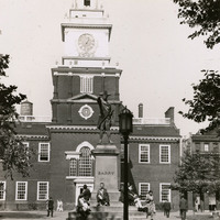
Caption: "Independence Hall -- Phila. July 31, 1934." A view of the steeple and bell tower of Independence Hall in Philadelphia, site of the debate over and signing of both the Declaration of Independence and the U.S. Constitution. Completed in 1753 for the use of the Pennsylvania Province's colonial legislature, it was also the site of a 1915 convention marking the formation of the League to Enforce Peace, predecessor entity to the United Nations. The Georgian-style building, designed by Edmund Woolley and Andrew Hamilton, has undergone several renovations. Only the central portion of the building is original -- all other portions of the building have been rebuilt at some point in its past. This building also housed the Liberty Bell until 1976, when the bell was moved to the Liberty Bell Center across the street.
Date: 7/31/1934
-
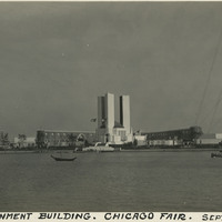
Caption: "Government Building. Chicago Fair. Sept. 18, 1934." View of the Federal Building at Chicago's Century of Progress Exposition, as seen from across the harbor. The three tall towers represent the three branches of the federal government. This building, towering over the Exposition, was featured on a commemorative US Postage Stamp issued in honor of the Exposition. A world fair attended by thirty-nine million people, the Expo celebrated Chicago's one-hundred year anniversary of incorporation. Originally planned to only run from May to November in 1933, it was such a success that its organizers decided to keep it running for a second season from May through October the following year. The central theme of the Exposition was technological innovation, with a motto of "Science Finds, Industry Applies, Man Conforms."
Date: 9/18/1934