Bookmarks
Showing Bookmarks 1 to 17 of 17
-
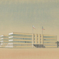
Preliminary design and drawing of state office building on N Street, Sacramento, by Alfred Eichler. Built to later design. Project for Department of Finance - Buildings and Grounds - Office Buildings.
Date: 1937
-
Hand-drawn sketch map of Cienega de los Paicines boundaries. Volume 1, page 228.
Date: 1835
-
Hand-drawn sketch map of Jimeno, or Salsipuedes, or Santa Paula y Saticoy boundaries. Volume 2, page 97.
Date: 1844
-
Hand-drawn sketch map of Orestimba boundaries. Volume 2, page 41.
Date: 1844
-
Hand-drawn sketch map of Blosa del Chamizal boundaries. Volume 2, page 174.
Date: 1837
-
Hand-drawn sketch map of Estero Americano or Cañada de Mais boundaries. Volume 1, page 453.
Date: 1837
-
Hand-drawn sketch map of Agua Mansa boundaries. Volume 1, page 542.
Date: 1839
-
-
Caption: "Fallen Giant - Mariposa Grove," c. 1917. Grace McCarthy poses with two unidentified people next to the Fallen Monarch, the enormous trunk of a fallen Giant Sequoia in Maripose Grove. It is estimated that the tree fell more than 300 years ago, but the natural resistance of Giant Sequoias to rot has preserved the trunk to the present time.
Date: 1917
-
Caption: "Sketch of Ward Building, Stockton State Hospital." Design and drawing by Alfred Eichler. Built in 1946. Project for Department of Mental Hygiene - Hospitals.
Date: 1940
-
Caption: "Bronze Plaque for Lincoln Barracks Yountville." Design and drawing for Veterans Home, Yountville, by Alfred Eichler. Project for Department of Veterans Affairs.
Date: 1929
-
Hand-drawn sketch map of Cañada Honda boundaries. Volume 1, page 170.
Date: 1834
-
Hand-drawn sketch map of Cañadas or San Julian boundaries. Volume 2, page 26.
Date: 1841
-
Hand-drawn sketch map of Santa Ana del Chino Sobrante boundaries. Volume 2, page 181.
Date: 1843
-
Caption: "Typical Barracks." California Maritime Academy, shore base, wartime building construction. Design and color drawing by Alfred Eichler. Built. Project for Department of Education.
Date: 1942
-
Hand-drawn sketch map of Rio de los Molinos boundaries. Volume 2, page 87.
Date: 1844
-
Hand-drawn sketch map of Land-valley of Temecula boundaries. Volume 2, page 83.
Date: 1844