Bookmarks
Showing Bookmarks 1 to 24 of 24
-
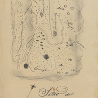
Hand-drawn sketch map of Conejo Rancho, or Nuesta Senora de Altagracia boundaries. Volume 1, page 324.
Date: 1834
-
Hand-drawn sketch map of Rincon de la Ballena boundaries. Volume 1, page 538.
Date: 1839
-
Caption: "Yuba River Scene.," c. 1920. Mountain scene with graveled road at left and river at right.
Date: 1920
-
Caption: "Carson City." Street scene with Grace McCarthy standing next to an automobile.
Date: 1927
-
Caption: "View of Fair Grounds, Portland." This photograph shows several buildings of the Lewis and Clark Centennial Exposition, including the Foreign Palace (foreground), the Oriental Palace to its left, and the darkly-colored Forestry Building at the far left. The exposition was held in Portland, Oregon from June 1st to October 15th, 1905. It celebrated the one-hundred year anniversary of the exploratory expedition of the Louisiana Purchase and what became the northwestern part of the United States, led by Meriwether Lewis and William Clark. Some 1.6 million people visited the fair, viewing exhibits from twenty-one countries.
Date: 1905
-
Hand-drawn sketch map of Canada de la Berrenda boundaries. Volume 2, page 195.
Date: 1846
-
Caption: "Bush Gardens, Pasadena," c. 1915., shows Grace and William McCarthy relaxing in chairs at Bush Gardens in Pasadena.
Date: 1915
-
Hand-drawn sketch map of Monterey River boundaries. Volume 1, page 96.
Date: 1834
-
Caption: "K Street Sacramento. Weinstock Lubins Store," Sacramento, California, c. 1910.
Date: 1910
-
-
-
-
Caption: "Los Angeles -- San Bernardino Boulevard.," c. 1915-1916. Grace McCarthy standing near automobile parked on country road under large oak tree.
Date: 1915
-
Hand-drawn sketch map of Corral de Tierra boundaries. Volume 1, page 476.
Date: 1839
-
No Caption: Palace of Horticulture, Panama-Pacific International Exposition.
Date: 1915
-
Caption: "Stow Lake. Golden Gate Park.," c. 1910. Created in 1893 as part of Golden Gate Park, this man-made lake surrounds Strawberry Hill Island. Several pleasure rowboats appear in this photograph.
Date: 1910
-
Caption: "Niagara River Tourist Camp. Niagara, New York. Sept. 10, 1934." William McCarthy standing next to an automobile in an early auto camp near Niagara Falls.
Date: 9/10/1934
-
Caption: " Educational Building," with marching band and Tower of Jewels in the background at the Panama-Pacific International Exposition.
Date: 1915
-
Hand-drawn sketch map of Agua Caliente boundaries. Volume 2, page 7.
Date: 1841
-
-
Caption: "Notre Dame College. South Bend, Indiana. Sept. 14, 1734 [sic], Sept. 14, 1934." Founded in 1842 and officially chartered in 1844, the University of Notre Dame is a Catholic research university famous world-wide for the quality of the education it provides. This photograph shows the Main Building's domed tower, (just to the right of center), and the steeple of the Basilica of the Sacred Heart (center), the university's on-site Catholic Church.
Date: 9/14/1934
-
Hand-drawn sketch map of Rio de los Putos boundaries. Volume 1, page 732.
Date: 1842
-
-
Hand-drawn sketch map of Sanjones, or Zanjones boundaries. Volume 1, page 440.
Date: 1839