Bookmarks
Showing Bookmarks 1 to 20 of 20
-
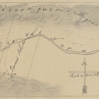
Hand-drawn sketch map of Caymus, or Paraje Napa boundaries. Volume 1, page 376.
Date: 1836
-
Caption: "Placerville," c. 1920. Street scene in Placerville. Automobiles mix with horses and wagons along the curbs.
Date: 1920
-
Hand-drawn sketch map of Caslamayomi or Laguna de los Gentiles boundaries. Volume 2, page 57.
Date: 1844
-
Caption: "Mountain Pack Burros," c. 1920. String of burros loaded with packs, with fields and trees in background. One young, unburdened burro stands off to the left of the main group.
Date: 1920
-
Hand-drawn sketch map of Medano or New York boundaries. Volume 1, page 498.
Date: 1839
-
No Caption. An unidentified man riding a horse at an unidentified location, c. 1920.
Date: 1920
-
Hand-drawn sketch map of Lihuaytos or Putos or Ulattis boundaries. Volume 2, page 110.
Date: 1843
-
-
-
No Caption: An unidentified man and woman standing in front of an automobile and large building at unidentified location, c. 1920.
Date: 1920
-
Hand-drawn sketch map of las Virgenes boundaries. Volume 1, page 109.
Date: 1833
-
Hand-drawn sketch map of Tajui, Agua Caliente or Valle de San Jose boundaries. Volume 1, page 618.
Date: 1840
-
-
No Caption: View of Point Loma Light. First lit in 1891, this light replaced the "Old Point Loma Lighthouse" that had been constructed in 1855 (see 96-07-08-alb08-225). The old lighthouse was often obscured by fog, so a new lighthouse was built at a lower elevation much closer to sea level, as can be seen in this photograph. The light was automated in 1973. See also 96-07-08-alb05-232.
Date: 1905
-
-
Hand-drawn sketch map of San Diego or San Deiguito boundaries. Volume 2, page 136.
Date: 1845
-
Drawing by Alfred Eichler of office building for Division of Highways. Project for Department of Public Works - Highways; district unidentified.
Date: undated
-
No Caption: c. 1898. View of Tillamook Rock Lighthouse and the small basalt rock upon which it sits, over one mile into the ocean from Tillamook Head. Built between 1880-1881, the treacherous ocean currents and often inclement weather associated with the area earned the lighthouse its nickname "Terrible Tillie" or "Tillie." This photograph was taken before the roof of the lighthouse was raised by five feet in 1898, to help prevent damage to the roof and the interior by crashing waves. The lighthouse was decommissioned in 1957.
Date: 1898
-
Public proclamation issued by H. C. Pratt of the Western Defense Command regarding rescission of various exclusions
Date: December 17, 1945
-
No Caption: See also 96-07-08-alb08-156 with caption: "Agricultural Building, Portland Fair, 1905." View of the Agriculture and Horticulture Building at the Lewis and Clark Centennial Exposition. The exposition was held in Portland, Oregon from June 1st to October 15th, 1905. It celebrated the one-hundred year anniversary of the exploratory expedition of the Louisiana Purchase and what became the northwestern part of the United States, led by Meriwether Lewis and William Clark. Some 1.6 million people visited the fair, viewing exhibits from twenty-one countries.
Date: 1905