Bookmarks
Showing Bookmarks 1 to 4 of 4
-
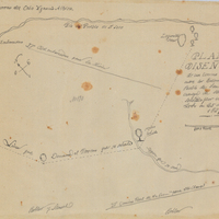
Hand-drawn sketch map of San Pedro y San Pablo boundaries. Volume 1, page 442.
Date: 1839
-
Hand-drawn sketch map of Punta de los Reyes boundaries. Volume 2, page 16.
Date: 1841
-
Caption: "California Coast Highway - Oxnard to Santa Monica, May 24, 1935."
Date: 1935
-
Caption: "Fort Casey Lake," c. 1906. Crockett Lake, on Whidbey Island in Puget Sound, with still waters reflecting trees from the shoreline.
Date: 1906