Bookmarks
Showing Bookmarks 1 to 25 of 27
-
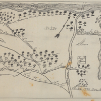
Hand-drawn sketch map of Rincon de San Francisquito boundaries. Volume 1, page 624.
Date: 1841
-
-
-
No Caption: undated. Photograph shows what appears to be a 12" disappearing coastal artillery gun, mounted on a rotating carriage.
Date: Undated
-
-
-
Caption: "Mojave Desert Cactus. Cayon [sic] Pass near Victorville," c. 1935, shows a Joshua Tree in bloom on the Cajon Pass near Victorville.
Date: 1935
-
Caption: "Silent City-Bryce Canyon National Park - View from Inspiration Point," c. 1935.
Date: 1935
-
Summary of the cooperation between various agencies in providing medical care; brief statement of policy
Date: Undated
-
Caption: "Saw Mill -- Astoria Oregon," c. 1905-1909. Saw mill on the Columbia River, near Astoria.
Date: 1905
-
Caption: "3" Barbett [sic] Gun," c. 1915. Side view of a barbette (gun emplacement) featuring a 3" heavy artillery gun (firing projectiles three inches in diameter).
Date: 1915
-
-
Caption: "Crater Lake and Wizard Island," c. 1935.
Date: 1935
-
-
Caption: "Unknown Soldiers Grave - Arlington Cemetry[sic]," c. 1925. The Tomb of the Unknown Soldier, also called the Tomb of the Unknowns, memorializes those U.S. military service members who died without their remains being later identified. The remains of the first Unknown Soldier, stemming from World War I and disinterred from a cemetery in France, were laid to rest in the tomb in 1921.
Date: 1925
-
Caption: "A.Y.P.E. Seattle Government Bldg." View of the Government Building and the Cascades (a terraced fountain leading up to the building), part of the Alaska-Yukon-Pacific Exposition. Held in Seattle to celebrate the development of the Pacific Northwest, the fair attracted 3.7 million visitors over the course of its run from June to October 1909. Although most of the fair's buildings have since been destroyed, several of them now serve as part of the University of Washington campus. See also 96-07-08-alb08-125.
Date: 1909
-
-
-
-
Caption: "Hermoso [sic] Dorothy Gandy. A youthful Mexican beauty."
Date: 1938
-
Hand-drawn sketch map of Asusa boundaries. Volume 1, page 638.
Date: 1841
-
-
-
-
Caption: "Saint Mary's Lake and going to the Sun Mountain. Glacier National Park," c. 1935.
Date: 1935