Bookmarks
Showing Bookmarks 1 to 5 of 5
-
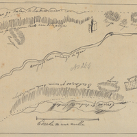
Hand-drawn sketch map of La Bolsa Chica boundaries. Volume 1, page 656.
Date: 1839
-
Hand-drawn sketch map of Najoque or Nojoguez boundaries. Volume 2, page 79.
Date: 1842
-
Hand-drawn sketch map of Cañada de los Osos y Pecho y Islae boundaries. Volume 2, page 183.
Date: 1843
-
Caption: "Stanford Stadium," c. 1921. Birdseye view of the Stanford Stadium, which opened in 1921. This stadium has since been replaced by a more modern facility built in 2005-2006.
Date: 1921
-
Caption: "On the Shasta Route, Cal.," c. 1910. Photograph likely taken from an observation car, showing a train running along a creek or river in a mountainous area. Given the caption, this is likely in the Siskiyou Mountains, Trinity Mountains, or the Cascade Range, but the specific location is unidentified.
Date: 1910