Bookmarks

Showing Bookmarks 1 to 5 of 5

  • Land- Santa Clara County or San Franciquito or San Francisquito Rancho

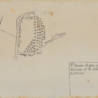
    Hand-drawn sketch map of Land- Santa Clara County or San Franciquito or San Francisquito boundaries. Volume 1, page 680.

    Date: 1839

  • McCarthy Album 07, Photograph 049

    Caption: "Arch, Court of the Universe, Eastern," at the Panama-Pacific International Exposition. See also 96-07-08-alb01-037.

    Date: 1915

  • Cañada de Raimundo Rancho

    Hand-drawn sketch map of Cañada de Raimundo boundaries. Volume 1, page 592.

    Date: 1839

  • McCarthy Album 05, Photograph 280

    Caption: "Venice," c. 1911. View of canal and bridge in Venice, California, with amusement "zone" in the distance. In 1905, Abbot Kinney built a series of canals as part of a development project along Santa Monica Beach, hoping to recreate the look and feel of Italy's iconic "Floating City" in southern California. Called Ocean Park at first, in 1911, the name officially changed to Venice. By 1929, however, many of the canals had been filled in to create roadways, and those that remained fell into disrepair. A revitalization movement in the early 1990s has restored some of the canals, and made the area a desirable residential neighborhood.

    Date: 1911

  • Rio de las Consumnes al Norte or Omachumnes Rancho

    Hand-drawn sketch map of Rio de las Consumnes al Norte or Omachumnes boundaries. Volume 2, page 109.

    Date: 1843