
Bookmarks
Showing Bookmarks 1 to 5 of 5
-
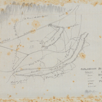
Hand-drawn sketch map of Puente or Puente de San Gabriel boundaries. Volume 1, page 702.
Date: 1840
-
-
-
-
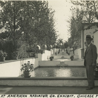
Caption: "Garden at American Radiator Co. Exhibit. Chicago [sic] Fair. Sept. 18, 1934." William McCarthy stands in front of a series of pools cascading into one another, surrounded by manicured plants at the Century of Progress Exposition. The Exposition, a world fair attended by thirty-nine million people, celebrated Chicago's one-hundred year anniversary of incorporation. Originally planned to only run from May to November in 1933, it was such a success that its organizers decided to keep it running for a second season from May through October the following year. The central theme of the Exposition was technological innovation, with a motto of "Science Finds, Industry Applies, Man Conforms."
Date: 9/18/1934