
Bookmarks
Showing Bookmarks 1 to 3 of 3
-
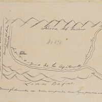
Hand-drawn sketch map of Cienega de los Paicines boundaries. Volume 1, page 778.
Date: 1840
-
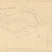
Hand-drawn sketch map of Cañada de los Osos y Pecho y Islae boundaries. Volume 2, page 143.
Date: 1843
-
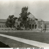
Caption: "Art Museum - Los Angeles," c. 1915. Located in Exposition Park, the Beaux Arts building, opened in 1913, was originally known as the Los Angeles Museum of History, Science, and Art. In 1963, the Los Angeles County Museum of Art moved to its current location on Wilshire Blvd. The Exposition Park facility became the Natural History Museum of Los Angeles County. After two years of renovation and restoration, it was reopened in 2009.
Date: 1915