
Bookmarks
Showing Bookmarks 1 to 7 of 7
-
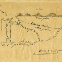
Hand-drawn sketch map of Arroyo Seco boundaries. Volume 2, page 3.
Date: 1840
-
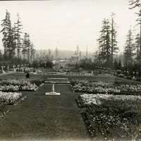
No Caption: View of a garden at the Alaska-Yukon-Pacific Exposition. Held in Seattle to celebrate the development of the Pacific Northwest, the fair attracted 3.7 million visitors over the course of its run from June to October 1909. Although most of the fair's buildings have since been destroyed, several of them now serve as part of the University of Washington campus.
Date: 1909
-

-
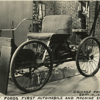
Caption: "Henry Ford's First Automobile and Machine Shop, Chicago Fair Exhibit. Sept. 19, 1934." This exhibit within the Ford Building at Chicago's Century of Progress Exposition replicated Henry Ford's original workshop, including a Quadricycle, the first automobile produced by Ford. The Exposition, a world fair attended by thirty-nine million people, celebrated Chicago's one-hundred year anniversary of incorporation. Originally planned to only run from May to November in 1933, it was such a success that its organizers decided to keep it running for a second season from May through October the following year. The central theme of the Exposition was technological innovation, with a motto of "Science Finds, Industry Applies, Man Conforms."
Date: 9/19/1934
-
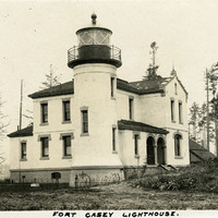
Caption: "Fort Casey Lighthouse.," c. 1909. Located on Whidbey Island in Puget Sound, the Admiralty Head Lighthouse was built overlooking Admiralty Inlet in 1903. It replaced an earlier structure that had to be moved in 1890 to accommodate the construction of Fort Casey. The second lighthouse, shown here, was built with thick walls in order to withstand earthquakes and the concussion of guns at Fort Casey. Deactivated in 1922, the lighthouse has since been restored by Washington State Parks, and is part of the Fort Casey State Park.
Date: 1909
-
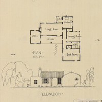
Plan and elevation for unidentified house by Alfred Eichler. Project for State Department of Public Works.
Date: 1929
-
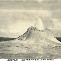
Caption: "Castle Geyser - Yellowstone," c. 1923. Castle Geyser erupting in Yellowstone National Park. The geyser's name refers to the shape of the cone around the vent.
Date: 1923