Bookmarks

Showing Bookmarks 1 to 6 of 6

  • San Lorenzo Rancho

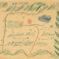
    Hand-drawn sketch map of San Lorenzo boundaries. Volume 2, page 10.

    Date: 1840

  • Aguichiumi Rancho

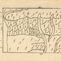
    Hand-drawn sketch map of Aguichiumi boundaries. Volume 2, page 61.

    Date: 1844

  • Tres Ojos de Agua Rancho

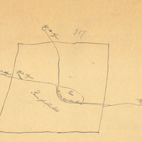
    Hand-drawn sketch map of Tres Ojos de Agua boundaries. Volume 2, page 48.

    Date: 1843

  • McCarthy Album 07, Photograph 004

    Caption: "Presidio S.F." See also 96-07-08-alb02-021. Entrance to the main post of the Presidio, San Francisco, c. 1910. Established in 1776 by Spanish explorers, the Presidio is a fortified location overlooking the Golden Gate, the entrance into San Francisco Bay. It was closed as a military structure in 1995, and is now a park within the Golden Gate National Recreation Area.

    Date: 1910

  • McCarthy Album 11, Photograph 003

    Caption: "Ocean Beach -- San Francisco, May 14, 1934." View of San Francisco's Ocean Beach, with a crowded parking lot in the foreground and the Cliff House (the fourth iteration of this San Francisco landmark) visible just to the right of the photograph's center. The date on this photograph may not be accurate, as several of the vehicles shown appear to date from later in the 1930s.

    Date: 5/14/1934

  • Santa Tomas Rancho

    Hand-drawn sketch map of Santa Tomas boundaries. Volume 2, page 163.

    Date: 1846