Bookmarks
Showing Bookmarks 1 to 5 of 5
-
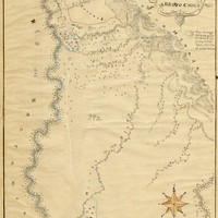
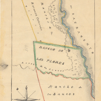
Hand-drawn sketch map of Arroyo Chico boundaries. Volume 2, page 75.
Date: 1844
-
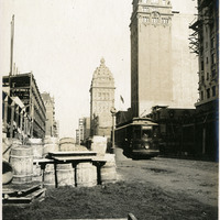
Caption: "Fourth and Market, One Year Later," 1907, shows much construction in progress, and completed, to the street and buildings one year after the 1906 earthquake and fires.
Date: 1907
-
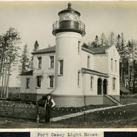
Caption: "Fort Casey Light House [sic]," c. 1905. Located on Whidbey Island in Puget Sound, the Admiralty Head Lighthouse was built overlooking Admiralty Inlet in 1903. It replaced an earlier structure that had to be moved in 1890 to accommodate the construction of Fort Casey. The second lighthouse, shown here, was built with thick walls in order to withstand earthquakes and the concussion of guns at Fort Casey. The man shown in the photograph is likely Charles H. Davis, who was appointed keeper of the lighthouse in 1900 and served until his death in 1914. The lighthouse, deactivated in 1922, has since been restored by Washington State Parks, and is part of the Fort Casey State Park. See also 96-07-08-alb03-065.
Date: 1905
-
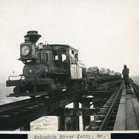
Caption: "Columbia River Jetty, Or.," c. 1910. View of a jetty built at the mouth of the Columbia River, carrying a railroad trestle. A train and its operators, hauling cars loaded with large rocks, dominates the photograph. This is likely the so-called South Jetty, extending more than six miles into the ocean from Point Adams on the Oregon side of the river mouth. The jetty system at the mouth of the Columbia River was constructed between 1885 and 1917. Designed to funnel water from the Columbia River in a more concentrated fashion into the Pacific Ocean, the jetty system helped create a deeper, more stable shipping channel.
Date: 1910
-