Bookmarks

Showing Bookmarks 1 to 6 of 6

  • Lomas de la Purification Rancho

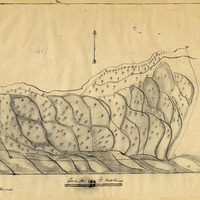
    Hand-drawn sketch map of Lomas de la Purification boundaries. Volume 2, page 91.

    Date: 1845

  • McCarthy Album 06, Photograph 166

    Caption: "Market Street Burning." A view of the Call Building on Market and 3rd Streets on fire after the 1906 earthquake, with people and horses in the foreground. Considered one of the worst natural disasters in the country's history, the 1906 San Francisco earthquake and resulting fires killed an estimated 3,000 people and destroyed over 500 city blocks, leaving approximately 200,000 residents homeless.

    Date: 1906

  • Ojo de Caballo, or Posolmi Rancho and Posita de las Animas Rancho

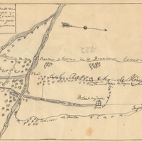
    Hand-drawn sketch map of Ojo de Caballo, or Posolmi Rancho and Posita de las Animas boundaries. Volume 2, page 108.

    Date: 1843

  • McCarthy Album 09, Photograph 008

    Caption: "State Capitol - Calif, " c. 1920. View of the California State Capitol Building. Much of the building is obscured by trees, but the dome is visible. Designed by M.F. Butler, California's State Capitol Building experienced significant delays while under construction. Crews broke ground on December 4, 1856, but the Legislature did not occupy the building until 1869, and the building was not fully completed until 1874.

    Date: 1920

  • McCarthy Album 04, Photograph 218

    Caption: "Midway Point.," c. 1920. Now-iconic image of a rocky outcropping near Pebble Beach, extending into the Pacific Ocean, with a single cypress tree near the top. This tree, sometimes referred to as the "Lone Cypress," has been photographed extensively over the past century. This tree and outcropping can still be seen as part of the 17-Mile Drive, a scenic road tour of the Pebble Beach Resort area in Monterey County.

    Date: 1920

  • Nietos Addition Rancho

    Hand-drawn sketch map of Nietos Addition boundaries. Volume 2, page 205.

    Date: 1846