Bookmarks
Showing Bookmarks 1 to 16 of 16
-
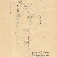
Hand-drawn sketch map of Potreros de la Sierra del Agua Caliente, or Poteros de San Juan Capistrano boundaries. Volume 2, page 120.
Date: 1845
-
-
-
-
-
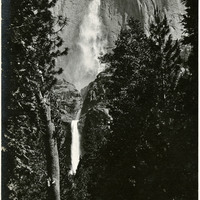
Caption: "Yosemite Falls," c. 1917. Grace McCarthy two unidentified friends pose for a photograph on the trail to Yosemite Falls. Both Upper and Lower Fall can be seen in this photograph. The highest waterfall in Yosemite National Park, Yosemite Falls is made up of two successive cascades falling a total of 2,425 feet from the top of the Upper Fall to the base of the Lower Fall. The Upper Fall alone is 1,430 feet high, and is one of the top twenty highest waterfalls in the world.
Date: 1917
-
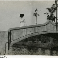
Caption: "Venice, Calif," c. 1911. Unidentified woman standing on a bridge over Lion Canal in Venice, California. In 1905, Abbot Kinney built a series of canals as part of a development project along Santa Monica Beach, hoping to recreate the look and feel of Italy's iconic "Floating City" in southern California. Called Ocean Park at first, gondoliers sailed boats under elegant bridges such as the one shown in this photograph, in an effort to attract businesses, residents, and investors. In 1911, the name officially changed to Venice. By 1929, however, many of the canals had been filled in to create roadways, and those canals that remained fell into disrepair. A revitalization movement in the early 1990s has restored some of the canals, and made the area a desirable residential neighborhood.
Date: 1911
-
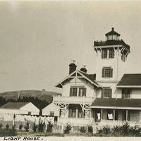
Caption: "Point Firmin [sic] Lighthouse," c. 1915, shows the Point Fermin lighthouse, built in 1874 in San Pedro Bay, which was the first navigational light into the bay. It served as a federally-operated lighthouse until 1927, when its operations were turned over to the City of Los Angeles. After the bombing of Pearl Harbor in 1941, the west coast was blacked out for fear of being an easy target to enemy forces. It was never lit again, but during WWII it served the U.S. Navy as a lookout tower and signaling station for ships coming into the San Pedro Bay. In 2003, the lighthouse was opened after being restored, retrofitted, and rehabilitated for public use. It is listed on the National Register of Historic Places and managed by the Department of Recreation and Parks of the City of Los Angeles.
Date: 1915
-
-
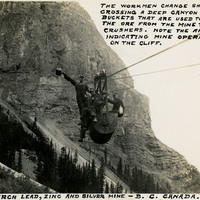
Caption: "The Monarch Lead, Zinc, and Silver Mine - B.C. Canada. The workmen change shifts by crossing a deep canyon in the buckets that are used to transport the ore from the mine to the rock crushers. Note the arrows indicating mine operations on the cliff," c. 1935.
Date: 1935
-
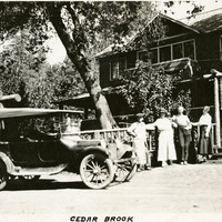
Caption: "Cedar Brook," c. 1920. William and Grace McCarthy (at left) standing with two unidentified people, with house in background and automobile next to them.
Date: 1920
-
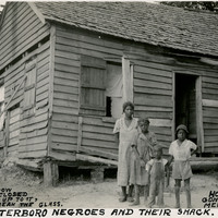
Caption: "Walterboro Negroes and Their Shack. If the Window Wont [sic] Stay Closed, Put a Stick Up to It, You Wont [sic] Break the Glass. House Foundation Gone But They Live Merrily On. July 17, 1934." Unidentified family posing in front of a dilapidated home in Walterboro.
Date: 7/17/1934
-
-
-
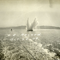
Caption: "#2 -- Record Oct 25, 09." This postcard shows plume of seawater thrown up by a mortar shell during target practice at Fort Point. The facilities at Fort Point were part of an effort by the U.S. government to protect the Golden Gate, entrance to the San Francisco Bay. Built between 1853-1861, the fort included emplacements for 141 guns but never fired a weapon in defense of the Bay. Its name was officially changed in 1882 to Fort Winfield Scott. This only lasted four years, however, for in 1886 the fort was officially downgraded to a sub-post of the San Francisco Presidio and the name discontinued. It was resurrected in 1912, however, with the establishment of a coastal artillery fortification at the Presidio, called, once again, Fort Winfield Scott.
Date: 1909-10-25
-