
Bookmarks
Showing Bookmarks 1 to 2 of 2
-
-
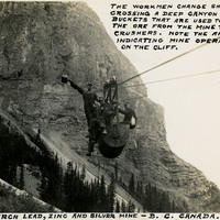
Caption: "The Monarch Lead, Zinc, and Silver Mine - B.C. Canada. The workmen change shifts by crossing a deep canyon in the buckets that are used to transport the ore from the mine to the rock crushers. Note the arrows indicating mine operations on the cliff," c. 1935.
Date: 1935