Bookmarks
Showing Bookmarks 1 to 25 of 26
-
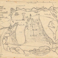
Hand-drawn sketch map of Roblar de las Miseria boundaries. Volume 2, page 151.
Date: 1844
-
Hand-drawn sketch map of Former lands of Mission Delores, or San Pablo, or Cuchiosmos, or Cuchiguenos, or Cuduyunes boundaries. Volume 1, page 38.
Date: 1834
-
-
Caption: "Shoe Room Door - Garbage Room." Pacific State Hospital. Design and drawing by Alfred Eichler. Built. Project for Department of Mental Hygiene - Hospitals. The hospital was initially named Pacific Colony (1927-1953), followed by Pacific State Hospital (1953-1979); Frank D. Lanterman State Hospital and Developmental Center; and finally Lanterman Developmental Center, which closed in 2015.
Date: 1934
-
Hand-drawn sketch map of Cañada de Capay boundaries. Volume 2, page 177.
Date: 1845
-
Caption: "East Column of Main Entrance." Drawing of Science Building Addition, Downtown Campus, San Francisco State College; design and drawing by Alfred Eichler. Built. Project for Department of Education.
Date: 1935
-
Hand-drawn sketch map of Pilarcitos boundaries. Volume 1, page 224.
Date: 1835
-
Hand-drawn sketch map of Land- Monterey county, or Lomas del Carmelo or Meadows Tract boundaries. Volume 2, page 29.
Date: 1833
-
Caption: "Supts. Res. Pac. Colony." Drawing of Library, Superintendent's residence, Pacific State Hospital; design and drawing by Alfred Eichler, c. 1932. Project for Department of Mental Hygiene - Hospitals. The hospital was initially named Pacific Colony (1927-1953), followed by Pacific State Hospital (1953-1979); Frank D. Lanterman State Hospital and Developmental Center; and finally Lanterman Developmental Center, which closed in 2015.
Date: 1932
-
Preliminary design and drawing of state office building on N Street, Sacramento, by Alfred Eichler. Built to later design. Project for Department of Finance - Buildings and Grounds - Office Buildings.
Date: 1937
-
Hand-drawn sketch map of Cienega de los Paicines boundaries. Volume 1, page 228.
Date: 1835
-
Hand-drawn sketch map of Jimeno, or Salsipuedes, or Santa Paula y Saticoy boundaries. Volume 2, page 97.
Date: 1844
-
Hand-drawn sketch map of Orestimba boundaries. Volume 2, page 41.
Date: 1844
-
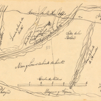
Hand-drawn sketch map of Blosa del Chamizal boundaries. Volume 2, page 174.
Date: 1837
-
Hand-drawn sketch map of Estero Americano or Cañada de Mais boundaries. Volume 1, page 453.
Date: 1837
-
Hand-drawn sketch map of Agua Mansa boundaries. Volume 1, page 542.
Date: 1839
-
-
Caption: "Fallen Giant - Mariposa Grove," c. 1917. Grace McCarthy poses with two unidentified people next to the Fallen Monarch, the enormous trunk of a fallen Giant Sequoia in Maripose Grove. It is estimated that the tree fell more than 300 years ago, but the natural resistance of Giant Sequoias to rot has preserved the trunk to the present time.
Date: 1917
-
Caption: "Sketch of Ward Building, Stockton State Hospital." Design and drawing by Alfred Eichler. Built in 1946. Project for Department of Mental Hygiene - Hospitals.
Date: 1940
-
Caption: "Bronze Plaque for Lincoln Barracks Yountville." Design and drawing for Veterans Home, Yountville, by Alfred Eichler. Project for Department of Veterans Affairs.
Date: 1929
-
Hand-drawn sketch map of Cañada Honda boundaries. Volume 1, page 170.
Date: 1834
-
Hand-drawn sketch map of Cañadas or San Julian boundaries. Volume 2, page 26.
Date: 1841
-
Hand-drawn sketch map of Santa Ana del Chino Sobrante boundaries. Volume 2, page 181.
Date: 1843
-
Caption: "Typical Barracks." California Maritime Academy, shore base, wartime building construction. Design and color drawing by Alfred Eichler. Built. Project for Department of Education.
Date: 1942
-
Hand-drawn sketch map of Rio de los Molinos boundaries. Volume 2, page 87.
Date: 1844