Bookmarks

Showing Bookmarks 1 to 25 of 32

  • Teletype

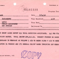
    February Enemy Alien report; number of cases and amount paid

    Date: March 14, 1946

  • McCarthy Album 11, Photograph 110

    Caption: "P. and O. R.R. Key West to Miami -- Florida. July 2, 1934." View of railroad tracks running over water to an island in the distance. This is likely part of the Overseas Railroad, an extension of the Florida East Coast Railway, built to connect Key West with the Florida mainland.

    Date: 7/2/1934

  • Consumnes or Rancho de Hartnell Rancho

    Hand-drawn sketch map of Consumnes or Rancho de Hartnell boundaries. Volume 2, page 103.

    Date: 1844

  • Santa Margarita Rancho

    Hand-drawn sketch map of Santa Margarita boundaries. Volume 1, page 672.

    Date: 1840

  • San Antonio Rancho

    Hand-drawn sketch map of San Antonio boundaries. Volume 1, page 314.

    Date: 1838

  • Pilarcitos or Las Pilarcitos Rancho

    Hand-drawn sketch map of Pilarcitos or Las Pilarcitos boundaries. Volume 1, page 88.

    Date: 1833

  • McCarthy Album 04, Photograph 107

    Caption: "Capistrano Mission," c. 1915-1916. Ruins of the Mission San Juan Capistrano, founded in 1776.

    Date: 1915

  • McCarthy Album 09, Photograph 219

    Caption: "Traymore Hotel - Atlantic City," c. 1925. View of the Traymore Hotel on the Atlantic City Boardwalk. The Art Deco-style Traymore began as a small boarding house, but a rebuild and enlargement after a storm in 1884 led to the building becoming Atlantic City's most popular hotel by the turn of the twentieth century. In 1906 the front tower was constructed, and the back, wood frame portion of the hotel was replaced with a concrete structure in 1914-1915. Patronage declined in the 1960s, and the Traymore Hotel was demolished in 1972.

    Date: 1925

  • Canada de los Alisos Rancho

    Hand-drawn sketch map of Canada de los Alisos boundaries. Volume 2, page 197.

    Date: 1845

  • eichler_f3274_324_7

    Drawing of typical physicians' residence for California state institutions. Design and drawing by Alfred Eichler. Project for Department of Mental Hygiene - Hospitals.

    Date: 1928

  • San Juan Bautista Rancho

    Hand-drawn sketch map of San Juan Bautista boundaries. Volume 2, page 58.

    Date: 1843

  • San Clemente or Tamalpais Rancho

    Hand-drawn sketch map of San Clemente or Tamalpais boundaries. Volume 2, page 122.

    Date: 1845

  • Tulucay Rancho

    Hand-drawn sketch map of Tulucay boundaries. Volume 1, page 690.

    Date: 1840

  • Cañada de Salsipuedes Rancho

    Hand-drawn sketch map of Cañada de Salsipuedes boundaries. Volume 2, page 64

    Date: 1844

  • McCarthy Album 02, Photograph 063

    No Caption: See also 96-07-08-alb08-114 with caption: "Ferry Boat Tacoma on the Columbia River," Pacific Northwest, c. 1905. View of the railroad ferry Tacoma, with a train on board. The Tacoma operated from 1884 until 1908, when a railroad bridge was constructed across the Columbia River, connecting Portland, Oregon, with points north of the river.

    Date: 1905

  • Punta del Monte, or Rincon de la Monte or Rincon del la Punta de Monte de la Soledad Rancho

    Hand-drawn sketch map of Punta del Monte, or Rincon de la Monte, or Rincon del la Punta de Monte de la Soledad boundaries. Volume 1, page 140.

    Date: 1836

  • McCarthy Album 10, Photograph 072

    Caption: "Botanical Garden Building - San Diego Exposition," 1935, shows the Botanical Building and Conservatory with reflecting pool that featured lilies, begonias, fuchsias, and a variety of ferns at the California-Pacific International Exposition.

    Date: 1935

  • Old Series Trademark No. 2894

    ["D" in a diamond]

    Date: 1897

  • Sanel Rancho

    Hand-drawn sketch map of Sanel boundaries. Volume 2, page 90.

    Date: 1844

  • Puente or Puente de San Gabriel Rancho

    Hand-drawn sketch map of Puente or Puente de San Gabriel boundaries. Volume 1, page 702.

    Date: 1840

  • Jamacha, or Jamacho Rancho

    Hand-drawn sketch map of Jamacha, or Jamacho boundaries. Volume 1, page 36.

    Date: 1833

  • Sotoyome Rancho

    Hand-drawn sketch map of Sotoyome boundaries. Volume 1, page 674.

    Date: 1840

  • McCarthy Album 06, Photograph 004

    No caption. Photograph of a forest in the foreground and a granite mountain in the distance, at an unidentified location.

    Date: Undated

  • McCarthy Album 05, Photograph 253

    Caption: "Street Scene -- Ogden," c. 1916. Street scene in Ogden, Utah, with mountains in the background. Tracks and lines for electric trolleys or streetcars can be seen, as well as automobiles and several local businesses.

    Date: 1916

  • McCarthy Album 10, Photograph 300

    Caption: "Happy Isles - Yosemite National Park," c. 1935, shows an unidentified rushing river.

    Date: 1935