
Bookmarks
Showing Bookmarks 1 to 3 of 3
-
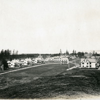
No Caption: See also 96-07-08-alb08-139 with caption: "Fort Stevens, Or," c. 1910. A view of buildings at Fort Stevens, part of the Three Fort Harbor Defense System protecting the mouth of the Columbia River from enemy incursion or attack (the other forts being Fort Columbia and Fort Canby, both in Washington). Built during the Civil War, the fort remained active until after World War II. In June 1942, Fort Stevens gained the dubious distinction of being the only military installation in the continental United States to come under enemy fire when a Japanese submarine surfaced off the coast and fired seventeen missiles at the fort. The missiles destroyed the backstop to the fort's baseball field, but otherwise did little harm. Fort Stevens was decommissioned in 1947. It was later turned over to the Oregon Parks and Recreation Department, and currently is the site of an Oregon State Park.
Date: 1910
-
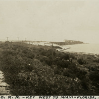
Caption: "P. and O. R.R. -- Key West to Miami -- Florida. July 2, 1934." View of railroad tracks carried on a berm in the foreground and on a trestle over water in the distance. This is likely part of the Overseas Railroad, an extension of the Florida East Coast Railway, built to connect Key West with the Florida mainland.
Date: 7/2/1934
-
Correspondence from Robert G. Sproul to John H. Tolan regarding summary and thoughts on "Preliminary Report and Recommendations on Problems of Evacuation of Citizens and Aliens from Military Areas," a report issued by the Tolan Committee
Date: April 7, 1942