Bookmarks
Showing Bookmarks 1 to 17 of 17
-
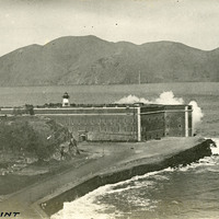
Caption: "Fort Point," c. 1910. This postcard shows a view of Fort Point, at the entrance to San Francisco Bay. The facilities at Fort Point were part of an effort by the U.S. government to protect the Golden Gate, entrance to the San Francisco Bay. Built between 1853-1861, the fort included emplacements for 141 guns but never fired a weapon in defense of the Bay. Its name was officially changed in 1882 to Fort Winfield Scott, but in 1886 the fort was officially downgraded to a sub-post of the San Francisco Presidio and the name discontinued. It was resurrected in 1912, with the establishment of a coastal artillery fortification at the Presidio, called, once again, Fort Winfield Scott.
Date: 1910
-
-
Caption: "General View - Panama Pacific International Exposition."
Date: 1915
-
No Caption: See also 96-07-08-alb08-140 with caption: "Fort Columbia, Wash." c. 1910. Fort Columbia, built between 1896 and 1904, sits on Chinook Point overlooking the Columbia River. It is part of the Three Fort Harbor Defense System protecting the mouth of the river from enemy incursion or attack (the other forts being Oregon's Fort Stevens and Washington's Fort Canby). Fort Columbia was decomissioned after World War II, and is now the site of a Washington State Park.
Date: 1910
-
Caption: "Tatoosh Mountain Range - Rainier National Park Lodge," c. 1935.
Date: 1935
-
Hand-drawn sketch map of San Miguel boundaries. Volume 2, page 155.
Date: 1845
-
Hand-drawn sketch map of Cuyama or Cuyoma boundaries. Volume 2, page 203.
Date: 1846
-
Caption: "Canyon and Trestle Mt Tamalpais RR.," c. 1907. Muir Woods Railway, established in 1896 as a scenic tourist railway between Mill Valley and the east peak of Mount Tamalpais in Marin County.
Date: 1907
-
Caption: "San Diego Courthouse.," c. 1905. View of the second courthouse built by San Diego County, completed in 1889. Designed by architectural firm Cornstock & Trotsche of San Francisco, this elaborate building featured a bell and clock tower, statues of four presidents, and 42 stained-glass windows honoring each state in the Union at the time of installation. The tower was removed in 1939. Twenty years later, the entire building was demolished in favor of a newer facility.
Date: 1905
-
Hand-drawn sketch map of Llano Seco boundaries. Volume 2, page 145.
Date: 1844
-
Hand-drawn sketch map of Potrero or San Jacinto Nuevo y Potrero or San Jacinto Sobrante boundaries. Volume 2, page 157.
Date: 1845
-
Caption: "View of Chicago From Boston Store Bldg," c. 1923. State Street, the Chicago Theatre, and the Wrigley Building (still under construction) can be seen in this bird's eye view of Chicago.
Date: 1923
-
Caption: "Yacht Harbor," on the San Francisco Bay outside the Panama-Pacific International Exposition. See also 96-07-08-alb01-075.
Date: 1915
-
Hand-drawn sketch map of Nietos Addition boundaries. Volume 2, page 205.
Date: 1846
-
Hand-drawn sketch map of Salinas y Visitacion boundaries. Volume 1, Page 2.
Date: 1834
-
-
Hand-drawn sketch map of Sayent or Zaygente or Zayanta boundaries. Volume 1, page 196.
Date: 1833