Bookmarks
Showing Bookmarks 1 to 7 of 7
-
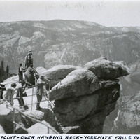
Caption: "Glacier Point - Over Hanging Rock - Yosemite Falls In The Distance," c. 1935. A group of unidentified people looking out from Glacier Point. Both Upper and Lower Yosemite Fall are visible across the valley at the right side of the photograph. Glacier Point, on the south wall of the valley 3,200 feet above what is now known as Half Dome Village, provides panoramic views of the valley and many of its features. By the time this photograph was taken, safety railings had been installed at the Point to prevent visitors from tumbling over the cliff while trying to get the best views.
Date: 1935
-
No Caption: In this 1935 photograph, the opening of the Wawona highway tunnel frames the Yosemite Valley with El Capitan (the Captain) on the left, Bridalveil Falls on the right, and Half Dome in the distance.
Date: 1935
-
Hand-drawn sketch map of Cañada de San Geronimo or Rancho de San Geronimo boundaries. Volume 2, page 36.
Date: 1839
-
-
Caption: "Louisiana Highway, June 12, 34." A highway in Louisiana recedes into the distance, flanked by tall vegetation.
Date: 6/12/1934
-
Caption: "Old Geary Street Line -- Last Days Work of our Old Faithful Friend." Photograph of a horse-drawn cable car, on the last day of operation of the Geary Street, Park and Ocean Railway. One of the first railways established in San Francisco, the line operated from 1880 until May 1912 when it was taken over by the city and converted to an electric streetcar line.
Date: 1912-05
-
Correspondence from Azile H. Aaron to Charles M. Wollenberg regarding using resettlement assistance funds to purchase garden tools
Date: August 8, 1945