
Bookmarks
Showing Bookmarks 1 to 7 of 7
-
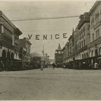
No Caption: shows a street scene in Venice, California, c. 1915.
Date: 1915
-
-
-
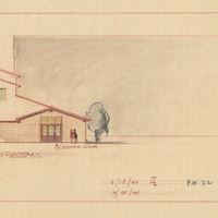
Caption: "West Elevation." Color drawing of postwar building, California School for the Deaf at Berkeley. Design and drawing by Alfred Eichler, 1944; built in 1946. Project for Department of Education.
Date: 1944
-
Samson, Free and Easy, Vulcan, Monitor, Confidence, Equality, Faithful, Reliance, Wearwell, Rival, Chesterfield, Prize Medal
Date: 1887
-
-
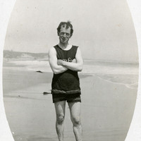
No caption, c. 1906. William McCarthy in a swim suit on a beach, with surf and waves in the background.
Date: 1906