Bookmarks
Showing Bookmarks 1 to 2 of 2
-
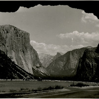
No Caption: In this 1935 photograph, the opening of the Wawona highway tunnel frames the Yosemite Valley with El Capitan (the Captain) on the left, Bridalveil Falls on the right, and Half Dome in the distance.
Date: 1935
-
Caption: "Hopland-Clear Lake Highway," c. 1925. Birdseye view of the Hopland Grade (also called the Hopland Pass), now part of California State Route 175 connecting Hopland (Mendocino County) with Lakeport on Clear Lake, in Lake County. The road, built in the early 1920s, is sometimes called the "crookedest road in California."
Date: 1925