Bookmarks
Showing Bookmarks 1 to 25 of 29
-
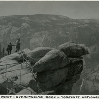
Caption: "Glacier Point - Overhanging Rock - Yosemite National Park," c. 1935, shows people standing on the overhanging rock of Glacier Point.
Date: 1935
-
-
"Report on Revolving Fund Advances for Assistance to Enemy Aliens and Others Affected by Restrictive Governmental Actin as of October 31, 1945"
Date: November 1, 1945
-
Correspondence from Charles M. Wollenberg to Beulah L. Lewis regarding eligibility for CWA
Date: September 20, 1946
-
No Caption: A big tree at Yosemite National Park, c. 1935.
Date: 1935
-
Hand-drawn sketch map of Land- Mission San Luis Obispo boundaries. Volume 2, page 190.
Date: 1843
-
Caption: "Echo Park [sic] Los Angeles," c. 1910. William McCarthy standing on a bridge in Los Angeles' Echo Lake Park. The park opened in 1895. The lake was originally created in 1868 to support the operations of a mill. The mill, however, closed seven years later. The site was later selected for conversion to a city park.
Date: 1910
-
Hand-drawn sketch map of San Luicito boundaries. Volume 1, page 668.
Date: 1840
-
Caption: "Boulder City," c. 1935, shows the municipality originally constructed for workers of the Boulder Dam.
Date: 1935
-
Caption: "Foot Bridge," c. 1917. A pedestrian bridge spans the Merced River as it tumbles over and through chunks of granite and rock in Yosemite National Park.
Date: 1917
-
-
Caption: "Mrs Eliza Smarts Home and Kin -- Chattahoochee, Florida, June 22, 34." Eliza Smart (standing, on the left), two unidentified women, and nine children posing on the porch of a house with wood siding. This is one of the few photographs in which the McCarthys identified some of the people who they met along their travels.
Date: 6/22/1934
-
Caption: "Pt. Townsend Court House," Washington, c. 1908. See also 96-07-08-alb08-033. View of the Jefferson County Courthouse in Port Townsend, Washington. Built the early 1890s (W.A. Ritchie, architect), the Romanesque-style building features a 124-foot clock tower, red bricks from St. Louis, and sandstone from Alaska.
Date: 1908
-
-
-
-
-
-
No Caption: Shows the grounds and buildings of the Hotel Del Monte resort in Monterey, California, c. 1915. See also 96-07-08-alb07-253.
Date: 1915
-
Caption: "Pajaro River, Watsonville," with railroad trestle in the background, c. 1910.
Date: 1910
-
Hand-drawn sketch map of Cañada de Herrera boundaries. Volume 1, page 432.
Date: 1839
-
Caption: "Turtle Pens -- Key West. July 2, 1934." View of turtle kraals, or turtle corrals, used in the turtle fishing industry in Key West. Green turtles were kept in these pens prior to slaughter or transport. Turtle meat and eggs were popular food items in the early-to-mid twentieth century; turtle fat was especially prized for making turtle soup. However, the turtle population plummeted in the Florida Keys and surrounding areas as the twentieth century progressed and demand increased. The turtle kraals and nearby canneries closed when the Endangered Species Act was passed in 1971. Populations have since started to recover. The cannery near the kraals shown in this photograph now serves as the Key West Turtle Museum.
Date: 7/2/1934
-
-
Hand-drawn sketch map of San Agustin boundaries. Volume 1, page 462.
Date: 1833
-