
Bookmarks
Showing Bookmarks 1 to 3 of 3
-
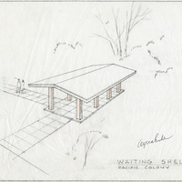
Caption: "Waiting Shelter - Pacific Colony." Design and drawing of waiting shelter, Pacific State Hospital, by Alfred Eichler. Project for Department of Mental Hygiene - Hospitals. The hospital was initially named Pacific Colony (1927-1953), followed by Pacific State Hospital (1953-1979); Frank D. Lanterman State Hospital and Developmental Center; and finally Lanterman Developmental Center, which closed in 2015.
Date: 1941
-
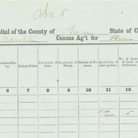
Image of Census of 1852, page 5 from Placer County Schedule II Volume I.
Date: 1852
-
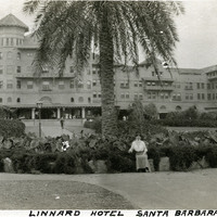
Caption: "Linnard Hotel Santa Barbara.," c. 1920. Grace McCarthy sitting in front of the Hotel Potter. Opened in 1903 by Milo M. Potter, the hotel sold in 1919 to the Santa Barbara Hotel Company, controlled by D.M. Linnard. The famous luxury resort burned down in 1921. See also 96-07-08-alb04-097.
Date: 1920