Bookmarks

Showing Bookmarks 1 to 9 of 9

  • Merced Rancho

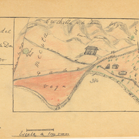
    Hand-drawn sketch map of Merced boundaries. Volume 2, page 71.

    Date: 1844

  • McCarthy Album 05, Photograph 005

    No caption, c. 1910. William McCarthy in striped suit and bowler hat, posing in garden for photograph.

    Date: 1910

  • McCarthy Album 05, Photograph 105

    No caption, c. 1910. Four large-caliber mortars with associated gun crews at target practice. See also 96-07-08-alb05-106 and 107.

    Date: 1910

  • McCarthy Album 05, Photograph 167

    Caption: "Circus Parade -- Santa Rosa, Calif.," c. 1905. This image shows several elephants walking down a street in Santa Rosa, part of the Ringling Brothers Circus, which first came to Santa Rosa in 1903. The traveling circus became an annual event in the town for the next two decades.

    Date: 1905

  • McCarthy Album 10, Photograph 392

    Caption: "Pan-American Highway monument marking the highway completion, July 1, 1936 Altitude 8209 feet. Highest point on route - 15 miles south of Octopan [sic], Mexico." Pictured is William McCarthy standing before the "Monument of Good Friendship (El Monumento de Buena Amistad), near Actopan, Mexico.

    Date: 1938

  • eichler_f3274_260

    Pencil drawing of entrance to New Governor's Mansion by Alfred Eichler. Not built. Project for Office of the Governor.

    Date: 1931

  • McCarthy Album 08, Photograph 042

    Caption: "The Olympic Snow-capped Mountains.," c. 1908-1912. View of a coastal inlet or tideland with raised roads, a large building (probably a resort hotel) in the middle distance, and the white-capped Olympic Mountains in the far distance.

    Date: 1908

  • eichler_f3274_372

    Caption: "Alfred Eichler design study." Study for historic landmark sign for California Division of Highways. These landmarks were created throughout the state of California. Project for Department of Natural Resources - Beaches and Parks.

    Date: 1946

  • Cañada del Cort de Madera, or San Emilio, (Emiglio), or Todos Santos Rancho

    Hand-drawn sketch map of Cañada del Cort de Madera, or San Emilio, (Emiglio), or Todos Santos boundaries. Volume 1, page 12.

    Date: 1833