Search William M. McCarthy Photograph Collection
- Filters:
- Type
- Still Image 3077
- Language
- English 3077
Search Results 1051 to 1060 of 3080
-
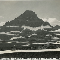
Caption: "Mount Reynolds - Logan Pass - Glacier National Park," c. 1935.
Date: 1935
-
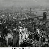
Caption: "East Side New York." Bird's eye view of New York City's Lower East Side and Two Bridges areas. The Brooklyn and Manhattan bridges span the East River in the right side of the photograph. See also 96-07-08-alb09-166.
Date: 1934
-
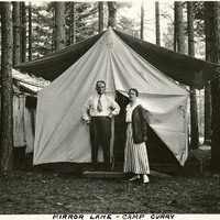
Caption: "Mirror Lane - Camp Curry," c. 1917. William and Grace McCarthy pose in front of their tent at what was then called Camp Curry. Yosemite's Half Dome Village, established by David and Jennie Curry in 1899, was originally called Camp Curry, and then later Curry Village. It was designed to provide cheaper accommodations for Yosemite tourists than the resort hotels. The couple rented out furnished tents and provided amenities such as a dining tent. As time progressed, the amenities increased, and some hard-sided cabins created.
Date: 1917
-
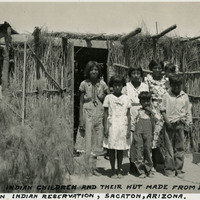
Caption: "Pima Indian Children and their hut made from bush branches, Sacaton Indian Reservation, Sacaton, Arizona," c. 1935. Located south of Phoenix and including the town of Sacaton, the Gila River Indian Reservation is home to members of the Akimel O’odham (Pima) and the Pee-Posh (Maricopa) tribes. The reservation was established in 1859. Eighty years later, in 1939, Congress provided for the self-governance of the reservation via the Gila River Indian Community.
Date: 1935
-
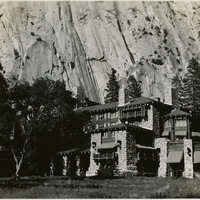
No Caption: The Ahwahnee Hotel opened in 1927. The rustic design (Gilbert Stanley Underwood, architect) is often described as "parkitecture," meaning it is meant to match its surroundings, like many structures in National Parks built in that era. The hotel was renamed the Majestic Yosemite Hotel in 2016.
Date: 1935
-
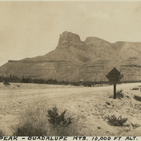
Caption: "Signal Peak -- Guadalupe Mts. 10,000 ft alt. New Mexico, May 29, 34." View of Guadalupe Peak (also known as Signal Peak), the highest natural point in Texas with an elevation of 8,751 feet above sea level.
Date: 5/29/1934
-
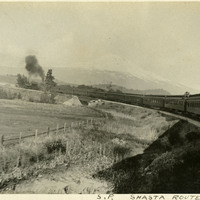
Caption: "S.P. Shasta Route." Southern Pacific train on the Shasta route with Mt. Shasta in the background, c. 1905.
Date: 1905
-
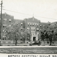
Caption: "Sisters Hospital -- Walla Walla.," ca. 1920. Five-story brick and stone building. This building is the second hospital built on the site. The first, built in the 1880s by the Sisters of Providence, burned in a 1915 fire. This second building (seen here), constructed in 1916, served as the main hospital building until a new facility was constructed in 1976. The resulting new complex of buildings is now called the Providence St. Mary Medical Center.
Date: 1920
-
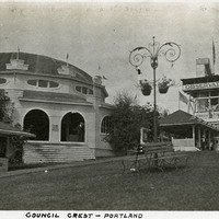
Caption: "Council Crest -- Portland," c. 1909. Buildings and benches in a park setting, with a tall observation tower, labeled the "Observatory," at the right side of the photograph. Council Crest Park in Portland, Oregon was the site of an amusement park between 1907 and 1929. The buildings in this photograph were part of that park. The Observatory, built in 1907, was demolished in 1941 to make room for a water tower. The area is still in use as a municipal park.
Date: 1909