Search All Items
- Filters:
- Type
- Image 1473
- Still Image 304
- Text 72
- Text 19
- Language
- English 1654
- Spanish 215
- ENGLISH 2
- English 1
- census_013 1
Search Results 1111 to 1120 of 1881
-
Office Memorandum from Harry B. White to Martha A. Chickering regarding meeting with Social Security board
Date: February 26, 1943
-
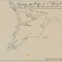
Hand-drawn sketch map of Rincon de San Pascual boundaries. Volume 1. page 564.
Date: 1840
-
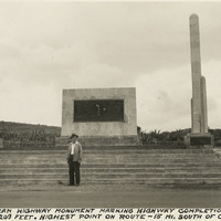
Caption: "Pan-American Highway monument marking the highway completion, July 1, 1936 Altitude 8209 feet. Highest point on route - 15 miles south of Octopan [sic], Mexico." Pictured is William McCarthy standing before the "Monument of Good Friendship (El Monumento de Buena Amistad), near Actopan, Mexico.
Date: 1938
-
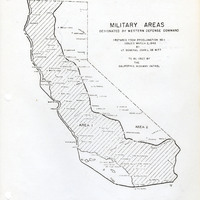
Map of California indicating boundaries for military areas prepared from Proclamation No. 1, issued by Lt. General John L. DeWitt to the California Highway Patrol
Date: Issued March 2, 1942