Search All Items
- Filters:
- Type
- Still Image 4044
- Image 3895
- Text 436
- Text 50
- Image of the California Census from the records of the office of the California Secretary of State 1
- Language
- English 7938
- Spanish 494
- ENGLISH 4
- English 2
- census_013 1
- contra_costa_schedule_1_volume_1 1
Search Results 2381 to 2390 of 8604
-
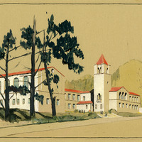
Design and color drawing of California School for the Blind at Berkeley by Alfred Eichler. Built. Project for Department of Education.
Date: 1930
-
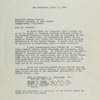
Correspondence from Earl Warren (by Chas. W. Johnson) to George Francis regarding voting rights of incarcerated Japanese
Date: April 1, 1942