Search All Items
- Filters:
- Type
- Still Image 4044
- Image 3895
- Text 436
- Text 50
- Image of the California Census from the records of the office of the California Secretary of State 1
- Language
- English 7938
- Spanish 494
- ENGLISH 4
- English 2
- census_013 1
- contra_costa_schedule_1_volume_1 1
Search Results 2681 to 2690 of 8604
-
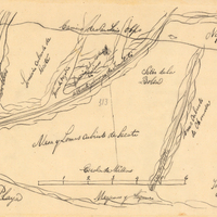
Hand-drawn sketch map of Blosa del Chamizal boundaries. Volume 2, page 174.
Date: 1837
-
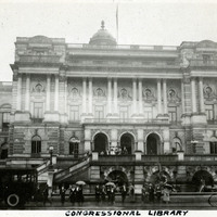
Caption: "Congressional Library," c. 1925. Several groups of unidentified people outside the Thomas Jefferson Building of the Library of Congress, on a rainy day. The building, originally called the Library of Congress Building, opened to the public in 1897. It's name was changed in 1980 to honor Thomas Jefferson, Founding Father and third President of the U.S.
Date: 1925
-
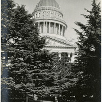
No caption, c. 1910. View of the California State Capitol Building. Trees obscure much of the building.
Date: 1910
-
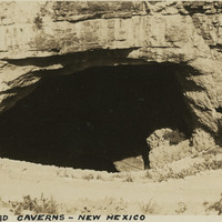
Caption: "Carlsbad Caverns -- New Mexico, May 30, 34." View looking into dark cave mouth of Carlsbad Cavern, a series of natural underground chambers including the "Big Room," the fifth-largest such chamber in North America with a length of 1,000 feet, a width of 625 feet, and a maximum height of 255 feet. The site was named Carlsbad Cave National Monument in 1923, and declared Carlsbad Caverns National Park in 1930.
Date: 5/30/1934
-
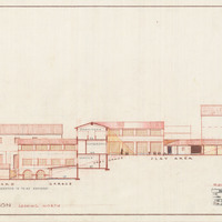
Caption: "Kindergarten. Transverse Section looking North." Scheme No. 7., color drawing of California School for the Deaf at Berkeley. Design and drawing by Alfred Eichler, 1944; built in 1946. Project for Department of Education.
Date: 1944
-
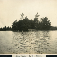
Caption: "Stow Lake, G.G. Park," c. 1906. A man-made lake created in 1893 as part of Golden Gate Park. The lake surrounds Strawberry Hill Island, seen in the center of this photograph. Visitors still enjoy Stow Lake today, engaging in activities such as boating and picnicking.
Date: 1906
-
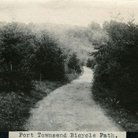
Caption: "Port Townsend Bicycle Path.," c. 1910. Image of a rural path or road, surrounded by trees and vegetation, with a hill in the distance. The bicycle made its first appearance in the Puget Sound area in the late 1870s. Within twenty years, thousands of enthusiasts had adapted the new mode of transportation. Such enthusiasts often formed clubs, such as the Queen City Good Roads Club, based in Seattle (south of Port Townsend). These clubs advocated, constructed, and helped to maintain pathways dedicated specifically to bicycle traffic. Ironically, the efforts made by the bicyclists to generally improve roadways contributed to the rise of another new mode of transportation -- the automobile.
Date: 1910