Search All Items
- Filters:
- Type
- Still Image 4044
- Image 3895
- Text 436
- Text 51
- Image of the California Census from the records of the office of the California Secretary of State 1
- Language
- English 7939
- Spanish 494
- ENGLISH 4
- English 2
- census_013 1
- contra_costa_schedule_1_volume_1 1
Search Results 3231 to 3240 of 8605
-
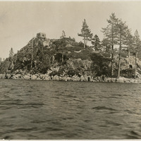
No Caption: c. 1935. Fannette Island is located in Emerald Bay, on the west shore of Lake Tahoe. In 1928, Mrs. Lora Josephine Knight purchased the property encompassing the head of Emerald Bay and Fannette Island. Knight had a summer home built in Scandinavian architectural style and called it Vikingsholm. The stone structure at the top of Fannette island is the "Tea House," built in 1928-1929, at the same time Vikingsholm was built.
Date: 1935