Search All Items
- Filters:
- Type
- Still Image 4044
- Image 3895
- Text 436
- Text 51
- Image of the California Census from the records of the office of the California Secretary of State 1
- Language
- English 7939
- Spanish 494
- ENGLISH 4
- English 2
- census_013 1
- contra_costa_schedule_1_volume_1 1
Search Results 3401 to 3410 of 8605
-
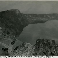
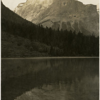
Caption: "Crater Lake, Oregon - View from Watchman Point," c. 1935. Located in the Crater Lake National Park, Crater Lake is a caldera lake formed about 7,700 years ago by the collapse of the volcano, Mount Mazama. Its 1,949 foot depth makes it the deepest lake in U.S.
Date: 1935
-
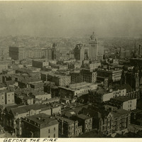
Caption: "S.F. Before the Fire," shows the central city of San Francisco before the 1906 earthquake and fires, 1906.
Date: 1906
-
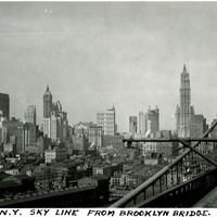
Caption: "N.Y. Sky Line From Brooklyn Bridge." View of New York City's skyline, as seen from the Brooklyn Bridge. A portion of the bridge (designed by architect John Augustus Roebling and completed in 1883) can be seen in the right hand side of the photograph. See also 96-07-08-alb09-165.
Date: 8/7/1934
-
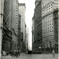
Caption: "Broadway At Bowling Green N.Y." Street scene in New York City, showing Broadway near the small public park Bowling Green. See also 96-07-08-alb04-076 and 96-07-08-alb11-233.
Date: 8/31/1934
-
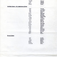
Report on number of cases; Sections: Active Cases; Service Cases; Closed Cases"; for similar report see F3729_73_002
Date: March 9, 1942
-
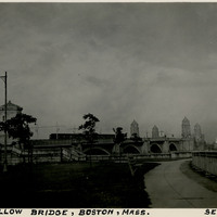
Caption: "Longfellow Bridge, Boston, Mass. Sept. 5, 1934." The Longfellow Bridge spans the Charles River between Boston and Cambridge. Originally called the Cambridge Bridge, it replaced a wood structure called the West Boston Bridge that had been constructed in 1793. This wood bridge was unable to handle large volumes of traffic or the introduction of street cars, so a new bridge was built in the early twentieth century. Opened in 1906 as the Cambridge Bridge, the name was changed in 1927 to the Longfellow Bridge in honor of poet Henry Wadsworth Longfellow. It is colloquially known as the Salt and Pepper Bridge, as its central towers are reminiscent in shape of salt and pepper shakers.
Date: 9/5/1934