Search All Items
- Filters:
- Type
- Image 1691
- Still Image 155
- Text 128
- Text 19
- Language
- English 1941
- Spanish 54
- ENGLISH 2
- English 1
- census_013 1
Search Results 351 to 360 of 2010
-
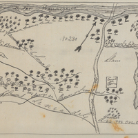
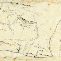
Hand-drawn sketch map of Pauma or Potreros de Paoma boundaries. Volume 2, page 77.
Date: 1844
-
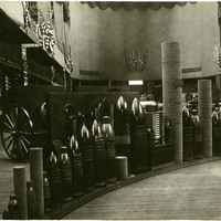
No Caption: See also 96-07-08-alb08-159 with caption: "Government exhibits of shot etc., Government Buidling." Portland Fair, Oregon, 1905. Exhibit of various types of heavy ordnance shells, including armor piercing shells as well as torpedoes. The exhibit was located in the Government Building of the Lewis and Clark Centennial Exposition, held in Portland, Oregon from June 1st to October 15th, 1905. It celebrated the one-hundred year anniversary of the exploratory expedition of the Louisiana Purchase and what became the northwestern part of the United States, led by Meriwether Lewis and William Clark. Some 1.6 million people visited the fair, viewing exhibits from twenty-one countries.
Date: 1905
-
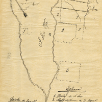
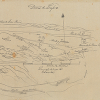
Hand-drawn sketch map of Rincon de San Francisquito boundaries. Volume 1, page 624.
Date: 1841
-
Office Memorandum from Ruth E. Rogers to Bertha S. Underhill regarding closure of Lomita Housing Project
Date: July, 3, 1946
-
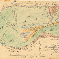
Hand-drawn sketch map of Cuyama or Cuyoma boundaries. Volume 2, page 202.
Date: 1846
-
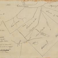
Hand-drawn sketch map of Chupucanes, or Monte del Diablo boundaries. Volume 1, page 140.
Date: 1827