Search All Items
- Filters:
- Type
- Still Image 4044
- Image 3895
- Text 436
- Text 51
- Image of the California Census from the records of the office of the California Secretary of State 1
- Language
- English 7939
- Spanish 494
- ENGLISH 4
- English 2
- census_013 1
- contra_costa_schedule_1_volume_1 1
Search Results 4181 to 4190 of 8605
-
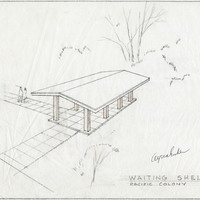
Caption: "Waiting Shelter - Pacific Colony." Design and drawing of waiting shelter, Pacific State Hospital, by Alfred Eichler. Project for Department of Mental Hygiene - Hospitals. The hospital was initially named Pacific Colony (1927-1953), followed by Pacific State Hospital (1953-1979); Frank D. Lanterman State Hospital and Developmental Center; and finally Lanterman Developmental Center, which closed in 2015.
Date: 1941
-
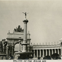
Caption: "Column of the Rising Sun," (Adolph A. Weinman, sculptor), at the Panama-Pacific International Exposition.
Date: 1915
-
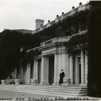
Caption: "Huntington Art Gallery- Los Angeles," c. 1935, shows Grace McCarthy standing before the Huntington Art Gallery building in San Marino, Los Angeles County.
Date: 1935
-
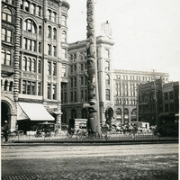
Caption: "Totem Pole, Seattle." Seattle, Washington, c. 1905. View of the Tlingit totem pole in Seattle's Pioneer Square. The totem pole was stolen in 1899 by a group of businessmen, and erected in the square, then known as Pioneer Place. An arsonist destroyed this pole in 1938, but it was later replaced by another carved by the Tlingit tribe (who were also finally paid for the original pole).
Date: 1905
-
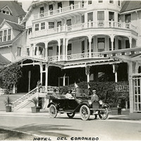
Caption: "Hotel del Coronado," c. 1915-1916. William and Grace McCarthy and unidentified man with automobile in front of the Hotel del Coronado. At the time it opened in 1888, this hotel was the largest beach resort in the world.
Date: 1915
-
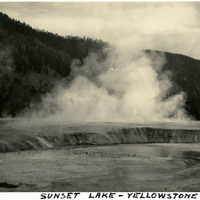
Caption: "Sunset Lake - Yellowstone," c. 1923. Yellowstone National Park's Sunset Lake is a shallow thermal pool in the Black Sand Basin. Its name is derived from the yellow and orange bands of bacteria and algae at its edges.
Date: 1923
-
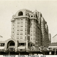
Caption: "Traymore Hotel - Atlantic City," c. 1925. View of the Traymore Hotel on the Atlantic City Boardwalk. The Art Deco-style Traymore began as a small boarding house, but a rebuild and enlargement after a storm in 1884 led to the building becoming Atlantic City's most popular hotel by the turn of the twentieth century. In 1906 the front tower was constructed, and the back, wood frame portion of the hotel was replaced with a concrete structure in 1914-1915. Patronage declined in the 1960s, and the Traymore Hotel was demolished in 1972.
Date: 1925