Search All Items
- Filters:
- Type
- Still Image 4044
- Image 3895
- Text 436
- Text 51
- Image of the California Census from the records of the office of the California Secretary of State 1
- Language
- English 7939
- Spanish 494
- ENGLISH 4
- English 2
- census_013 1
- contra_costa_schedule_1_volume_1 1
Search Results 4441 to 4450 of 8605
-
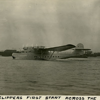
Caption: "The China Clippers [sic] First Start Across the Pacific Ocean. Nov. 22, 1935." View of the China Clipper, a Martin M-130 four-engine flying boat constructed for Pan American Airways in 1935. One of the largest planes of its time, the China Clipper flew the first transpacific commercial airmail flight between San Francisco and Manila in the Philippines. The China Clipper was destroyed in a crash ten years later, in January 1945, at the Port of Spain, Trinidad and Tobago.
Date: 11/22/1935