Search All Items
- Filters:
- Type
- Still Image 4044
- Image 3895
- Text 436
- Text 51
- Image of the California Census from the records of the office of the California Secretary of State 1
- Language
- English 7939
- Spanish 494
- ENGLISH 4
- English 2
- census_013 1
- contra_costa_schedule_1_volume_1 1
Search Results 5311 to 5320 of 8605
-
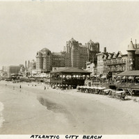
Caption: "Atlantic City Beach," c. 1925. Buildings and people line a beach in Atlantic City, including L.R. Adams Bath House (foreground at right), J.G. McGhory Co. 5 and 10 Cent Store (background at right); Franlingers (pavilion in center foreground), and the Traymore Hotel (center background).
Date: 1925
-
Hand-drawn sketch map of Land- Monterey county, or Lomas del Carmelo or Meadows Tract boundaries. Volume 1, page 518.
Date: 1839
-
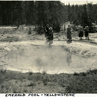
Caption: "Emerald Pool Yellowstone," c. 1923. Grace McCarthy (fourth from the right) and several unidentified people admire Emerald Pool in Yellowstone National Park. The pool, sometimes called Emerald Spring, is located in the park's Black Sand Basin. Yellow sulphur deposits, combined with the blue of the water, give the pool a vivid green color.
Date: 1923
-
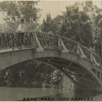
Caption: "Echo Park, Los Angeles," c. 1915, shows a man on a bridge in Echo Park, Los Angeles.
Date: 1915