Search All Items
- Filters:
- Type
- Still Image 4044
- Image 3895
- Text 436
- Text 51
- Image of the California Census from the records of the office of the California Secretary of State 1
- Language
- English 7939
- Spanish 494
- ENGLISH 4
- English 2
- census_013 1
- contra_costa_schedule_1_volume_1 1
Search Results 5981 to 5990 of 8605
-
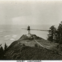
Caption: "Canby Lighthouse.," c. 1905-1909. The Cape Disappointment Lighthouse sits on a rocky point overlooking the mouth of the Columbia River. Built in the 1850s, the lighthouse was electrified in 1934 and automated in 1973. The lighthouse is now part of the Cape Disappointment State Park (formerly Fort Canby State Park).
Date: 1905
-
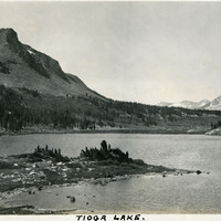
Caption: "Tioga Lake." Glacial lake in the Sierra Nevada Mountains, in Mono County, California, within the Inyo National Forest.
Date: 1927