Search All Items
- Filters:
- Type
- Still Image 4044
- Image 3895
- Text 436
- Text 50
- Image of the California Census from the records of the office of the California Secretary of State 1
- Language
- English 7938
- Spanish 494
- ENGLISH 4
- English 2
- census_013 1
- contra_costa_schedule_1_volume_1 1
Search Results 6771 to 6780 of 8604
-
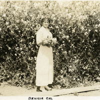
Caption: "Benicia Cal," c. 1905-1906. Grace McCarthy posing in garden with an armful of flowers.
Date: 1906
-
Caption: "Empire State Building in Center, Lower Manhattan in the Distance. View from Radio City Bldg. New York. Aug. 3, 1934." The Empire State Building dominates this bird's eye view of New York. Construction began on this iconic 102-story building, designed by William F. Lamb, in 1930. Completed by early 1931, it held the title of world's tallest building for almost 40 years, until being surpassed in 1970 by the construction of the World Trade Center's North Tower. It is now the fifth-tallest building in the U.S., and the 28th-tallest in the world.
Date: 8/3/1934