Search All Items
- Filters:
- Type
- Still Image 4044
- Image 3895
- Text 436
- Text 51
- Image of the California Census from the records of the office of the California Secretary of State 1
- Language
- English 7939
- Spanish 494
- ENGLISH 4
- English 2
- census_013 1
- contra_costa_schedule_1_volume_1 1
Search Results 7981 to 7990 of 8605
-
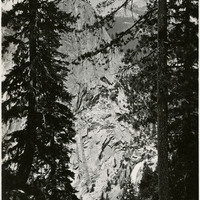
Caption: "Towering Trees and Cliffs - Yosemite," c. 1917. View of a granite mountain top as viewed through trees on a neighboring peak.
Date: 1917
-
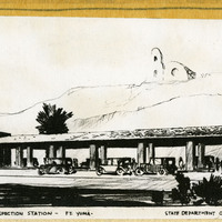
Caption: "Department of Agriculture - Plant Quarantine Inspection Station - Ft. Yuma. State Department of Public Works, Division of Architecture." Design and drawing by Alfred Eichler. Built in 1930. This was one of the first border stations and was situated in desert country; its purpose was to provide a stopping place for inspection of motor traffic coming into California in order to enforce quarantine against insect infestation of California agricultural products. Project for Department of Agriculture.
Date: 1930
-
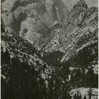
Caption: "Mountain Scene - Yosemite," c. 1917. Granite cliffs and evergreen trees dominate this photograph.
Date: 1917