Search All Items
- Filters:
- Type
- Still Image 4044
- Image 3895
- Text 436
- Text 50
- Image of the California Census from the records of the office of the California Secretary of State 1
- Language
- English 7938
- Spanish 494
- ENGLISH 4
- English 2
- census_013 1
- contra_costa_schedule_1_volume_1 1
Search Results 8021 to 8030 of 8604
-
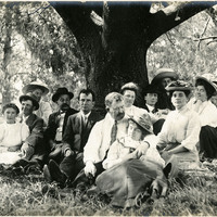
No Caption. Group photograph of eleven unidentified individuals, likely friends and family of the McCarthys, and William McCarthy (fifth from left in checkered suit) sitting at the base of a large oak tree, at an unidentified location, c. 1908.
Date: 1908
-
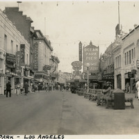
Caption: "Ocean Park - Los Angeles," c. 1935 shows a view of the Ocean Park Pier amusement zone in Santa Monica.
Date: 1935
-
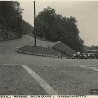
Caption: "Mohawk Trail, Hoosac Mountains, Massachusetts. Greenfield Mass to Albany New York, Sept 7, 1934." Hairpin turn on the Mohawk Trail, a scenic highway in Massachusetts. The Trail, originally a trade route for Native American tribes, was adopted as the route for the first scenic road constructed in the state. A gravel road was built along the route between 1912 and 1914, and later expanded as automobile traffic increased nation-wide. It is now part of Massachusetts Route 2.
Date: 9/7/1934