Search All Items
- Filters:
- Type
- Still Image 4044
- Image 3895
- Text 436
- Text 50
- Image of the California Census from the records of the office of the California Secretary of State 1
- Language
- English 7938
- Spanish 494
- ENGLISH 4
- English 2
- census_013 1
- contra_costa_schedule_1_volume_1 1
Search Results 2831 to 2840 of 8604
-
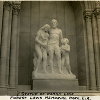
Caption: "Statue of Family Love, Forest Lawn Memorial Park. L.A.," c. 1935, shows Family Love (Ernesto Gazzeri, sculptor), on the grounds of Forest Lawn Memorial Park in Glendale, Los Angeles.
Date: 1935
-
Caption: "Mission Carmel," c. 1918, at Carmel-by-the-Sea in Monterey County, was established by Spanish Franciscans in 1770.
Date: 1918
-
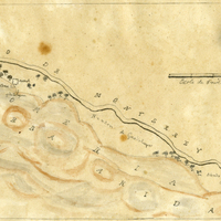
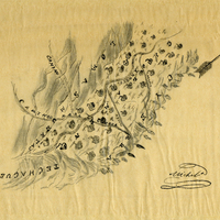
Hand-drawn sketch map of Llamitos de los Correos or Guadalupe y Llamitos de los Correos or Chular boundaries. Volume 1, page 48.
Date: 1831
-
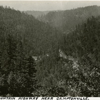
Caption: "The Mountain Highway Near Camptonville," c. 1920. Mountain scene, likely in or near Yuba County, California.
Date: 1920
-
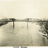
Caption: "Tacoma Bridge.," c. 1913. Double leaf, Rall-type bascule bridge spanning the Willamette River in Portland, Oregon. This is one of the rare instances where William McCarthy's labeling of the photographs in the albums is incorrect. The Broadway Bridge, built in 1913, was Portland's first bascule bridge, or drawbridge. It retains the distinction of being the longest bascule bridge span in the world.
Date: 1913
-
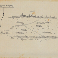
Hand-drawn sketch map of Cañada de San Ancelmo boundaries. Volume 1, page 554.
Date: 1839
-
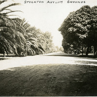
Caption: "Stockton Asylum Grounds," Stockton, California, c. 1906. The Stockton Insane Asylum was established in 1851, completed in 1853, and was the first public mental health hospital in California. It remained a functioning state hospital until 1995.
Date: 1906
-
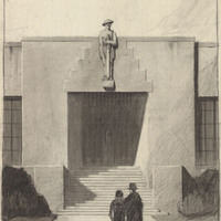
Caption: "Administrative Entrance - Armory - California National Guard - Long Beach." Design and drawing by Alfred Eichler. Project for California Military Department.
Date: 1930