Search All Items
- Filters:
- Type
- Still Image 4044
- Image 3895
- Text 436
- Text 51
- Image of the California Census from the records of the office of the California Secretary of State 1
- Language
- English 7939
- Spanish 494
- ENGLISH 4
- English 2
- census_013 1
- contra_costa_schedule_1_volume_1 1
Search Results 3481 to 3490 of 8605
-
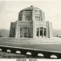
Caption: "Crown Point.," c. 1920. Shows the Vista House, built in 1918 as a memorial to Oregon's pioneers. Designed by Edgar M. Lazarus, it sits atop Crown Point, a rocky promontory overlooking the Columbia River gorge, along the Historic Columbia River Highway.
Date: 1920
-
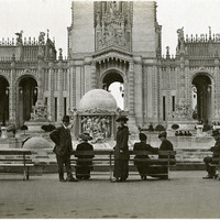
No Caption: William and Grace McCarthy standing in the Court of Abundance, at the Panama-Pacific International Exposition.
Date: 1915
-
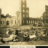
Caption: "Tannery Ruins, Benicia," c. 1905, shows the destroyed building of the Benicia Tannery.
Date: 1905