Search All Items
- Filters:
- Type
- Still Image 4044
- Image 3895
- Text 436
- Text 51
- Image of the California Census from the records of the office of the California Secretary of State 1
- Language
- English 7939
- Spanish 494
- ENGLISH 4
- English 2
- census_013 1
- contra_costa_schedule_1_volume_1 1
Search Results 6311 to 6320 of 8605
-
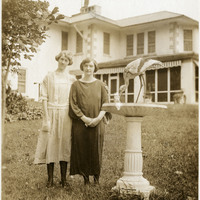
No caption. Grace McCarthy and an unidentified woman posing beside large bird bath or fountain, in front of the John Shields residence, in the Daybreak Estate area of Long Island.
Date: 8/27/1934
-
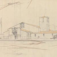
Design and drawing of unidentified California National Guard Armory by Alfred Eichler. Project for California Military Department.
Date: undated
-
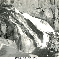
Caption: "Gibbons Falls," c. 1923. Yellowstone National Park's Gibbon Falls is located on the Gibbon River. The falls drop roughly eighty-four feet in a gradual descent.
Date: 1923
-
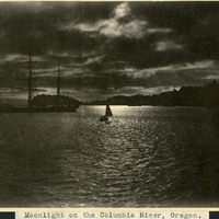
Caption: "Moonlight on the Columbia River, Oregon.," c. 1905. Photograph of the Columbia River at night. A cloudy sky nearly obscures the moon, but allows enough light to see a three-masted schooner and a small sailboat on the river.
Date: 1905
-
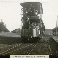
Caption: "Coronado Double Decker.," c. 1905. View of Car #41, a two-level trolley car operated by the San Diego Electric Railway in Coronado.
Date: 1905
-
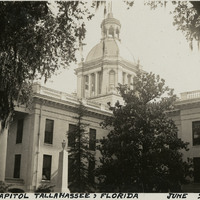
Caption: "State Capitol Tallahassee, Florida, June 23, 1934." View of the Florida State Capitol building, constructed in 1845. The dome, visible in the center of the photograph, was added in 1902. The building was altered and expanded several more times over the years, until a new State Capitol was built in the late 1970s. The old Capitol building was subsequently restored to its 1902 appearance and reopened to the public in 1982.
Date: 6/23/1934
-
Correspondence from Alice B. Guess to Bertha Underhill regarding difficulties in indexing public assistance recipients in Los Angeles County
Date: May 1, 1945
-
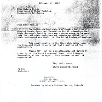
Correspondence from State Personnel Board to Sakaye Nishio regarding questionnaire given to all state employees of Japanese descent
Date: February 19, 1942