Search All Items
- Filters:
- Type
- Still Image 4044
- Image 3895
- Text 436
- Text 50
- Image of the California Census from the records of the office of the California Secretary of State 1
- Language
- English 7938
- Spanish 494
- ENGLISH 4
- English 2
- census_013 1
- contra_costa_schedule_1_volume_1 1
Search Results 6971 to 6980 of 8604
-
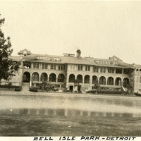
Caption: "Bell [sic] Isle Park - Detroit," c.1925. This photograph features the Belle Isle Casino, on the edge of Lake Tacoma on Belle Isle, in the Detroit River. The building is the second structure at the site, built in 1908 to replace a dilapidated wooden structure. The building is not a gambling facility, but is instead called a "casino" in the older sense of the word: a public building for meetings, dancing, reunions, and other recreation.
Date: 1925
-
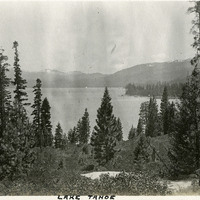
Caption: "Lake Tahoe." Scenic shot of Lake Tahoe and surrounding mountains.
Date: 1927
-
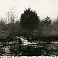
Caption: "Chetzemoka Park. Port Townsend." Washington, c. 1905.
Date: 1905
-
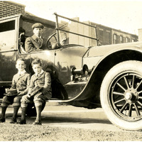
No caption. An unidentified man poses in the drivers seat of an automobile while two unidentified boys sit on the car's running boards.
Date: Undated
-
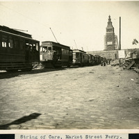
Caption: "String of Cars, Market Street Ferry," 1906. A view of cable cars, people, and a scaffolded Ferry Building at the end of Market Street, after the 1906 earthquake.
Date: 1906
-
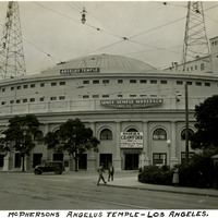
Caption: "Aimee McPherson's Angeles Temple- Los Angeles," c. 1935. Aimee Semple McPherson, also known as Sister Aimee was a Canadian-American Pentecostal evangelist and media celebrity in the 1920s and 1930s, famous for her theatrical sermons and claims of healing the sick, and for founding the Foursquare Church.
Date: 1935