Search All Items
- Filters:
- Type
- Still Image 4044
- Image 3895
- Text 436
- Text 50
- Image of the California Census from the records of the office of the California Secretary of State 1
- Language
- English 7938
- Spanish 494
- ENGLISH 4
- English 2
- census_013 1
- contra_costa_schedule_1_volume_1 1
Search Results 811 to 820 of 8604
-
Inter-Departmental Communication from State Personnel Board to W. T. Sweigert regarding return of Japanese and state employment
Date: June 12, 1945
-
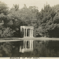
Caption: "Portals of the Past," c. 1915, on the shore of Lake Lloyd in Golden Gate Park, was originally the entranceway to the Nob Hill mansion of railroad tycoon, A.N. Towne. The entranceway was the only part of the home that was not destroyed by the 1906 earthquake and was moved to Golden Gate Park in 1909 as a reminder of much that was lost. See also 96-07-08-alb05-065.
Date: 1915
-
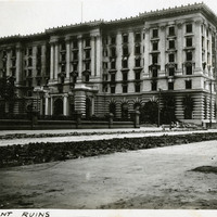
Caption: "Fairmount Ruins." Shows the damage from the 1906 earthquake fire to the Fairmont Hotel on Nob Hill in San Francisco, 1906. Although construction was mostly finished in 1906, the advent of the San Francisco earthquake and fire of that year damaged the hotel's interior and delayed opening until 1907. It was the first hotel in what is now the Fairmont Hotels and Resorts chain. In 1945, the San Francisco hotel was host to an international conference that culminated in the formation of the United Nations.
Date: 1906