Search All Items
- Filters:
- Type
- Still Image 4044
- Image 3895
- Text 436
- Text 51
- Image of the California Census from the records of the office of the California Secretary of State 1
- Language
- English 7939
- Spanish 494
- ENGLISH 4
- English 2
- census_013 1
- contra_costa_schedule_1_volume_1 1
Search Results 4901 to 4910 of 8605
-
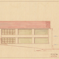
Caption: "North Elevation." Color drawing of postwar building, California School for the Deaf at Berkeley. Design and drawing by Alfred Eichler, 1944; built in 1946. Project for Department of Education.
Date: 1944
-
Caption: "Palm Beach -- View from Beach. July 8, 1934." View of Palm Beach's skyline and waterfront from a beach across the harbor.
Date: 7/8/1934
-
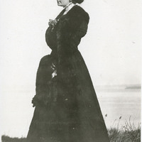
No caption, c. 1906. Unidentified woman in dark-colored dress with fur muff and stole, standing on grassy hill with ocean or lake in background.
Date: 1906
-
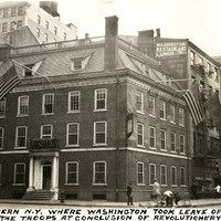
Caption: "Frances [sic] Tavern N.Y. Where Washington Took Leave Of Offices And Disbanded The Troops At Conclusion Of Revolutionery [sic] War." Built as a family home for Etienne "Stephen" DeLancey in 1719, this building was converted to use as a tavern in 1762. It served many important functions before, during, and after the Revolutionary War, but several fires in the nineteenth century erased the building's original appearance. The Sons of the Revolution purchased the property in 1904 and embarked upon extensive restoration plans in 1907, supervised by William Mersereau. The building is now used as a museum and art gallery. See also 96-07-08-alb11-203.
Date: 8/5/1934
-
Caption: "Cactus in Bloom Near Phoenix, Arizona," c. 1935, shows a large cactus in bloom and a bull resting nearby.
Date: 1935
-
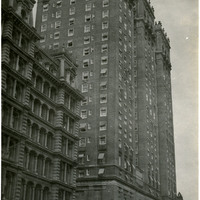
Caption: "Vanderbilt Hotel N.Y," c. 1925. Wealthy businessman Alfred Gwynne Vanderbilt, Sr. had the Vanderbilt Hotel constructed on the site of a former Vanderbilt residence in New York City, just six blocks from the new Grand Central Terminal. Designed by architects Warren & Wetmore, the hotel opened in 1912. The top two stories were constructed as a private residence for Vanderbilt's family. The hotel still stands today, although it has undergone some renovations.
Date: 1925
-
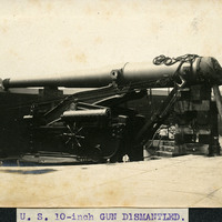
Caption: "U.S. 10-inch Gun Dismounted." A close-up view of a large gun that has been partially dismounted, at an unidentified coastal defense battery.
Date: Undated
-
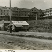
Caption: "Sea Beach Hotel," c. 1910. The Sea Beach Hotel, located on Beach Hill in Santa Cruz, was built in the 1870s by S.A. Hall. Originally called the Ocean View House, it was sold in the 1880s. Its new owner dubbed the building the Sea Beach Hotel. The resort hotel operated until burning down in 1912, never to be reconstructed.
Date: 1910
-
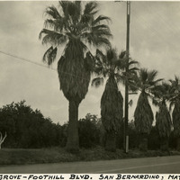
Caption: "Orange Grove - Foothill Blvd. San Bernardino, May 30, 1935." Shows an orange grove behind a row of stately palms on Foothill Blvd., also known as Route 66.
Date: 1935
-
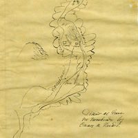
Hand-drawn sketch map of Cueras de Venado boundaries. Volume 1, page 24.
Date: 1834