Search All Items
- Filters:
- Type
- Image 2673
- Still Image 417
- Text 261
- Text 19
- Language
- English 3086
- Spanish 287
- ENGLISH 3
- English 1
- census_013 1
Search Results 231 to 240 of 3402
-
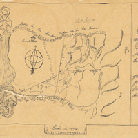
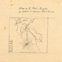
Hand-drawn sketch map of Rinconada de San Leandra or San Leandro boundaries. Volume 2, page 1.
Date: 1840
-
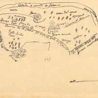
Hand-drawn sketch map of Cañada de Secuan or Mesa del Arroya or Valle de las Viejas boundaries. Volume 2, page 171.
Date: 1846
-
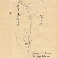
Hand-drawn sketch map of Potreros de la Sierra del Agua Caliente, or Poteros de San Juan Capistrano boundaries. Volume 2, page 120.
Date: 1845
-
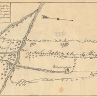
Hand-drawn sketch map of Ojo de Caballo, or Posolmi Rancho and Posita de las Animas boundaries. Volume 2, page 108.
Date: 1843
-
Hand-drawn sketch map of Island of San Diego or Peninsula of San Diego or North Island boundaries. Volume 2, page 193.
Date: 1846
-
Hand-drawn sketch map of Cañada del Rincon en el Rio San Lorenzo de Santa Cruz boundaries. Volume 2, page 170.
Date: 1843
-
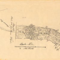
Hand-drawn sketch map of Carrisalitos, or Panoche de San Juan y Carrisalitos, or Rancho de San Juan y Carrisalitos boundaries. Volume 2, page 42.
Date: 1844
-
Caption: "A Key West Home Built of Corral [sic] Stone. July 2, 34." View of a multi-story residence made of coral.
Date: 7/2/1934
-
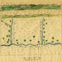
Hand-drawn sketch map of Moquelumnos, or Sanjon de los Moquelumnos or Rio de los Cosumnes al Sur boundaries. Volume 2, page 23.
Date: 1843
-
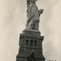
Caption: "Statue of Liberty, New York. Aug 2, 1934." View of the Statue of Liberty on Bedloe Island (now called Liberty Island). Designed by French sculptor Frédéric Auguste Bartholdi, the now-iconic statue was a gift from the people of France to the U.S. Built in segments in France by Gustave Eiffel (also famous for building the Eiffel Tower in Paris), the pieces were shipped from Paris to New York in 1885 and assembled. The Statue of Liberty was subsequently dedicated on October 28, 1886.
Date: 8/2/1934