Search All Items
- Filters:
- Type
- Image 2673
- Still Image 417
- Text 261
- Text 19
- Language
- English 3086
- Spanish 287
- ENGLISH 3
- English 1
- census_013 1
Search Results 241 to 250 of 3402
-
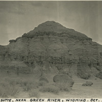
Caption: "Church Butte [sic], near Green River, Wyoming. Oct. 2, 1934." The Church Buttes in Wyoming consist of sandstone eroded by wind and weather into a butte approximately 1,000 feet in diameter and rising up to 100 feet above the surrounding valley floor. Located along the Overland Route used by emigrants to the West Coast, the formation gained additional notoriety for being a camp site for Brigham Young and the first Mormon party to head west, as well as a relay site for the Pony Express.
Date: 10/2/1934
-
Caption: "#2 -- Record Oct 25, 09." This postcard shows plume of seawater thrown up by a mortar shell during target practice at Fort Point. The facilities at Fort Point were part of an effort by the U.S. government to protect the Golden Gate, entrance to the San Francisco Bay. Built between 1853-1861, the fort included emplacements for 141 guns but never fired a weapon in defense of the Bay. Its name was officially changed in 1882 to Fort Winfield Scott. This only lasted four years, however, for in 1886 the fort was officially downgraded to a sub-post of the San Francisco Presidio and the name discontinued. It was resurrected in 1912, however, with the establishment of a coastal artillery fortification at the Presidio, called, once again, Fort Winfield Scott.
Date: 1909-10-25
-
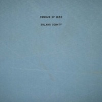
The Census of 1852 collection includes enumerations of California's 32 counties, arranged into 126 volumes. Schedule I enumerated the county's inhabitants, while schedule II enurmerated economic production. Many pages of this volume are damaged.
Date: 1852
-
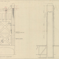
Final design drawing of transverse and longitudinal elevations for tower, M Street Bridge, by Alfred Eichler. The Tower Bridge replaced the M Street Bridge, which was removed in 1935. Project for Department of Public Works - Highways - Bridge Department.
Date: 1934